
West Nimba Community Forest
West Africa > Liberia > West Nimba Community Forest
Français | Português | Español | Bahasa Indonesia | Melayu
Summary
- Western chimpanzees (Pan troglodytes verus) are present in West Nimba Community Forest.
- The population size is 26 individuals.
- The chimpanzee population trend is unknown.
- This site has a total size of 105 km².
- Key threats to chimpanzees are large-scale mining and poaching.
- West Nimba has been removed from the list of proposed protected areas and become a community forest (Johnson 2015). At least one of three chimpanzee communities in West Nimba Community Forest lives directly west of one of the mining sites. The Nimba Mountains are an Alliance Zero Extinction (AZE) site.
Site characteristics
Nimba County is located in the western part of the Upper Guinea Ecoregion, which extends from Sierra Leone to the Sassandra River in Côte d’Ivoire. The West Upper Guinea forest ecosystem is characterized by exceptional biological richness and the endemism of its flora and fauna (CI 2012). West Nimba Community Forest is part of the Northern Nimba Conservation Area (NNCA), which is located in northeastern Liberia. The latter forms an integral part of the northeastern forest block of the country. The NNCA is comprised of the East Nimba Nature Reserve (ENNR), West Nimba Community Forest, ArcelorMittal Liberia (AML) concessions, and several towns. The area spans two districts of Nimba County: Yarmein and Gbelegay (CI 2012). Mount Nimba, which spans three countries, is one of the most famous sites for biodiversity conservation in West Africa and has been identified as a priority biodiversity hotspot for conservation (CI 2012). West Nimba was once designated a proposed protected area (Junker et al. 2015), but its protected status was modified later on (Johnson 2015). The following species were recorded in West Nimba Community Forest: western lesser spot-nosed monkey Cercopithecus petaurista buettikoferi, Campbell’s monkey Cercopithecus campbelli, sooty mangabey Cercocebus atys and the vulnerable king colobus Colobus polykomos, the near threatened bay duiker Cephalophus dorsalis and African buffalo Syncerus caffer, bush buck Tragelaphus scriptus, leopard Panthera pardus and African civet Civettictis civetta (CI 2012).
Table 1. Basic site information for West Nimba Community Forest
| Species | Pan troglodytes verus |
| Area | 105 km² |
| Coordinates | Lat: 7.48 , Lon: -8.71 |
| Type of site | Non-protected area (Community Forest) |
| Habitat types | Subtropical/tropical moist montane forest, Subtropical/tropical swamp forest, Subtropical/tropical heavily degraded former forest, Urban areas |
| Type of governance |
Types of sites Governance types Habitat types
Ape status
According to the literature, the area was first surveyed in 2005 by Fauna & Flora International (FFI), in collaboration with the Forestry Development Authority (FDA), the Environmental Protection Agency of Liberia (EPA), and the Ministry of Planning and Economic Affairs (MPEA). While chimpanzees were apparently recorded during this survey (CI 2012), no further details on the survey results could be found. During another survey conducted by Conservation International (CI), in collaboration with the Wild Chimpanzee Foundation (WCF), Actions pour la Conservation de la Biodiversité (ACB-CI), and AML
from 2010-2011, the study area was divided into three different sites: the Gangra-Yuelliton site (21.26 km²) where mining will be carried out, the Tokadeh site (19.88 km², under exploitation since May 2011) and the West Nimba site (79.97 km², the remaining West Nimba forest). The chimpanzee population was estimated at 26 individuals with a density of 0.21 chimpanzees/ km².
Table 2. Ape population estimates reported for West Nimba Community Forest
| Species | Year | Occurrence | Encounter or vistation rate (nests/km; ind/day) | Density estimate [ind./ km²] (95% CI) | Abundance estimate (95% CI) | Survey area | Sampling method | Analytical framework | Source | Comments | A.P.E.S. database ID |
|---|---|---|---|---|---|---|---|---|---|---|---|
| Pan troglodytes verus | 2010-2011 | 0.21 (0.05-0.55) | 26 (10-67) | West Nimba Community Forest (121 km²) | Line transects | CI 2012 (in collaboration with the WCF, ACB-CI, AML) | Survey effort: 122 km. Encounter rates: Gangra-Yuelliton:1.97; Tokadeh 0.4; West Nimba 0.74 | ||||
| Pan troglodytes verus | 2005 | Present | West Nimba Community Forest | Reconnaissance walk | FFI 2005 in Johnson 2015 | ‘BIOPA’ in CI 2012, Johnson 2015; ‘reconnaissance walk’; collaborative effort of FFI, FDA, EPA, MPEA (Johnson 2015) |
Sampling methods Analytical frameworks
Threats
Mount Nimba was exploited for iron ore by LAMCO from the 1960s until the early 1990s. A large part of West Nimba’s forest comprising the Gangra Mountain, the Yuelliton Mountain and the Tokadeh Mountain has been granted for iron ore mining to AML (CI 2012). AML holds a Class A mining licence, which entails that mining is permitted in the proposed production area (no size limit) for at least 25 years (Wilson et al. 2017). The 2010-2011 survey results showed that the chimpanzee distribution range overlaps largely with the mining sites (CI 2012). The bushmeat study that was conducted by CI (2012) in West Nimba Community Forest showed that hunting had a huge impact on wildlife in the area (CI 2012). Ancestral hunting methods had all but disappeared and been replaced by cable snares and shotguns year-round without regard for legislation. Traps accounted for 41% of the off-takes and caught both small and big game; guns, most of which were locally built, accounted for 58% of the off-takes and were used both day and night (CI 2012). The sources of water pollution are erosion at the mine site, waste dumps and stockpiles, oil and grease, discharge from settlement and attenuation ponds, and ore handling and loading. However, ore will not be processed for DSO Phase 1, which will eliminate some potential sources of pollution, but investigations revealed that the head of streams and downstream larger rivers would be affected (CI 2012).
Table 3. Threats to apes reported for West Nimba Community Forest
| Category | Specific threats | Threat level | Description | Year of threat |
|---|---|---|---|---|
| 2 Agriculture & aquaculture | 2.1 Annual & perennial non-timber crops | Medium (30-70% of population affected) | Cassava farms, cocoa farms, coffee farms, plantain farms, rice farms, new forest cutting and old farms (CI 2012). | Ongoing (2012) |
| 3 Energy production & mining | 3.2 Mining & quarrying | High (more than 70% of population affected) | Open-pit mining for iron ore (CI 2012). | Ongoing (2012) |
| 5 Biological resource use | 5.1 Hunting & collecting terrestrial animals | High (more than 70% of population affected) | Hunting signs recorded during line transect survey (CI 2012). | Ongoing (2012) |
| 5 Biological resource use | 5.3 Logging & wood harvesting | Medium (30-70% of population affected) | Logging signs recorded during line transect survey (CI 2012). | Ongoing (2012) |
| 9 Pollution | 9.2 Industrial & military effluents | High (more than 70% of population affected) | Water-, and air pollution caused by open-pit mining operations at this site (CI 2012). | Ongoing (2012) |
| 9 Pollution | 9.6 Energy emissions | High (more than 70% of population affected) | Noise from mining activities (CI 2012). | Ongoing (2012) |
Conservation activities
Challenges
Table 5. Challenges reported for West Nimba Community Forest
| Challenges | Specific challenges | Source | Year(s) |
|---|---|---|---|
| Not reported |
Enablers
Table 6. Enablers reported for West Nimba Community Forest
| Enablers | Specific enablers | Source | Year(s) |
|---|---|---|---|
| 1 Site management | |||
| 2 Resources and capacity | |||
| 3 Engaged community | |||
| 4 Institutional support | |||
| 5 Ecological context | |||
| 6 Safety and stability |
Research activities
Documented behaviours
Table 7. Behaviours documented for West Nimba Community Forest
| Category | Behavior | Observation type | Prevalence | Observation dates | Source | Habituation | Species | Comment |
|---|---|---|---|---|---|---|---|---|
| Not reported |
Exposure to climate change impacts
As part of a study on the exposure of African great ape sites to climate change impacts, Kiribou et al. (2024) extracted climate data and data on projected extreme climate impact events for the site. Climatological characteristics were derived from observation-based climate data provided by the Inter-Sectoral Impact Model Intercomparison Project (ISIMIP, www.isimip.org). Parameters were calculated as the average across each 30-year period. For 1981-2010, the EWEMBI dataset from ISIMIP2a was used. For the two future periods (2021-2050 and 2071-2099) ISIMIP2b climate data based on four CMIP5 global climate models were used. For future projections, two Representative Concentration Pathways (RCP) were used. RCP 2.6 is a scenario with strong mitigation measures in which global temperatures would likely rise below 2C. RCP 6.0 is a scenario with medium emissions in which global temperatures would likely rise up to 3C by 2100. For the number of days with heavy precipitation events, the 98th percentile of all precipitation days (>1mm/d) was calculated for the 1979-2013 reference period as a threshold for a heavy precipitation event. Then, for each year, the number of days above that threshold was derived. The figures on temperature and precipitation anomaly show the deviation from the mean temperature and mean precipitation for the 1979-2013 reference period.
The estimated exposure to future extreme climate impact events (crop failure, drought, river flood, wildfire, tropical cyclone, and heatwave) is based on a published dataset by Lange et al. 2020 derived from ISIMIP2b data. The same global climate models and RCPs as described above were used. Within each 30-year period, the number of years with an extreme event and the average proportion of the site affected were calculated (Kiribou et al. 2024).
Table 8. Estimated past and projected climatological characteristics in West Nimba Community Forest
| Value | 1981-2010 | 2021-2050, RCP 2.6 | 2021-2050, RCP 6.0 | 2071-2099, RCP 2.6 | 2071-2099, RCP 6.0 |
|---|---|---|---|---|---|
| Mean temperature [C] | 25 | 26.1 | 26.1 | 26.2 | 27.3 |
| Annual precipitation [mm] | 1930 | 1955 | 1991 | 1998 | 2070 |
| Max no. consecutive dry days (per year) | 33.9 | 31.6 | 30.4 | 33 | 33.8 |
| No. days with heavy precipitation (per year) | 6 | 8 | 7.3 | 8.2 | 9.7 |
Table 9. Projected exposure of apes to extreme climate impact events in West Nimba Community Forest
| Type | No. of years with event (2021-2050, RCP 2.6) | % of site exposed (2021-2050, RCP 2.6) | No. of years with event (2021-2050, RCP 6.0) | % of site exposed (2021-2050, RCP 6.0) | No. of years with event (2070-2099, RCP 2.6) | % of site exposed (2070-2099, RCP 2.6) | No. of years with event (2070-2099, RCP 6.0) | % of site exposed (2070-2099, RCP 6.0) |
|---|---|---|---|---|---|---|---|---|
| Crop failure | 7.5 | 5.96 | 6.5 | 5.96 | 7.5 | 5.96 | 17.5 | 5.96 |
| Drought | 0 | 0 | 0 | 0 | 0 | 0 | 0 | 0 |
| Heatwave | 7.5 | 100 | 5.5 | 100 | 6.5 | 100 | 6 | 100 |
| River flood | 0.5 | 0.08 | 1.75 | 0.88 | 2 | 1.46 | 4.5 | 1.39 |
| Tropical cyclone | 0 | 0 | 0 | 0 | 0 | 0 | 0 | 0 |
| Wildfire | 30 | 0.42 | 30 | 0.43 | 29 | 0.42 | 29 | 0.43 |
-
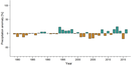
Precipitation anomaly in West Nimba Community Forest -
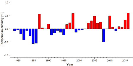
Temperature anomaly in West Nimba Community Forest


External links
References
Conservation International (CI) 2012. Further Ecological Studies as Part of the Environmental and Social Impact Assessment for Arcelormittal Liberia: Bushmeat and Biomonitoring Studies in the Northern Nimba Conservation Area. Unpublished report. Conservation International and ArcelorMittal, Liberia.
Johnson S. 2015. Aggregated Biodiversity Offsets: A Roadmap for Liberia’s Mining Sector. Unpublished report by the World Bank Group (WBG) and Program On Forests (PROFOR).
Junker, J., Boesch, C., Freeman, T., Mundry, R., Stephens, C., & Kühl, H. S. (2015). Integrating wildlife conservation with conflicting economic land-use goals in a West African biodiversity hotspot. Basic and Applied Ecology, 16(8), 690-702. doi:10.1016/j.baae.2015.07.002
Wilson, S. T. K., Wang, H., Kabenge, M., & Qi, X. (2017). The mining sector of Liberia: current practices and environmental challenges. Environmental Science and Pollution Research, 24(23), 18711-18720. doi:10.1007/s11356-017-9647-4
Kiribou, R., Tehoda, P., Chukwu, O., Bempah, G., Kühl, H. S., Ferreira, J., …, & Heinicke, S. (2024). Exposure of African ape sites to climate change impacts. PLOS Climate, 3(2), e0000345. doi:10.1371/journal.pclm.0000345
Page created by: APES Atlas Team Date: 2019-11-11