
Badiar National Park
West Africa > Republic of Guinea > Badiar National Park
Français | Português | Español | Bahasa Indonesia | Melayu
Summary
- Western chimpanzees (Pan troglodytes verus) are present in Badiar National Park.
- There is no estimate of chimpanzee abundance for this site.
- The chimpanzee population trend is unknown.
- This site has a total size of 1,228 km².
- Key threats to chimpanzees are logging and agricultural activities.
- The following conservation activities were conducted by the responsible park authority in cooperation with local villages: law enforcement.
- Badiar National Park is transboundary with the Niokolo-Koba National Park in Senegal.
Site characteristics
Badiar National Park (also referred to as Badiar Nord) is located in northern Guinea directly at the border to Senegal. It lies in the prefecture Koundara, just north of the town Koundara. Badiar was designated a National Park in 1985 (IUCN Category II) and is contiguous with Niokolo-Koba National Park in Senegal (UNEP-WCMC & IUCN 2019). It was initially created in an effort to reduce transboundary poaching (Brugière & Kormos 2009).
Badiar National Park is part of the Badiar Biosphere Reserve that has a total area of 2,843km2 and was established in 2002 (UNESCO MAB 2011). The biosphere reserve consists of three areas: Badiar National Park, Badiar South Classified Forest and N’Dama Classified Forest, as well as a buffer area and transition zone (UNESCO MAB 2011). The reserve provides refuge for 80 mammal species, 330 bird species as well as reptiles and fish (UNESCO MAB 2011).
Badiar lies at the transition between savanna and forested areas characterized by a mosaic of savanna, wooded savanna, open forests and gallery forests (WCF 2012, UNESCO MAB 2011). Two main rivers run through the area, the Koulountou and the Mitji. Areas around the rivers are occasionally inundated (BirdLife International 2019). Along parts of the rivers areas of palm trees can be found (BirdLife International 2019, WCF 2012). The average annual rainfall at the site is 1,000–1,500 mm (BirdLife International 2019).
An inventory of the flora and fauna of Badiar National Park found several plant and animal species listed by the IUCN Red List of Threatened Species, including leopard (Panthera pardus), lion (Panthera leo), hippopotamus (Hippopotamus amphibius), African wild dog (Lycaon pictus), African python (Python sebae) and Nile crocodile (Crocodylus niloticus) (Bailo et al. 2009). Threatened plant species include Ceiba pentandra, Combretum micranthum, and Cassia sieberiana. A biodiversity survey of Badiar in 2010 found a high density of ungulates, including harnessed bushbuck (Tragelaphus scriptus) and kob (Kobus kob), as well as a relatively high density of signs of carnivores, for example leopard (WCF 2012). Primate species that have been confirmed present in the park in addition to western chimpanzees include Guinea baboons (Papio papio), patas monkey (Erythrocebus patas), diana monkey (Cercopithecus diana), spot-nosed monkey (Cercopithecus petaurista), and western red colobus (Piliocolobus badius, Bailo et al. 2009, Brugière & Kormos 2009, WCF 2012). Badiar is also classified an important bird area (BirdLife International 2019).
Table 1. Basic site information for Badiar National Park
| Species | Pan troglodytes verus |
| Area | 1,228 km² |
| Coordinates | Lat: 12.5828 , Lon: -13.2860 |
| Type of site | Protected area (National Park) |
| Habitat types | Savanna, Shrubland, Subtropical/tropical dry forest, Wetlands (lakes, rivers, streams, bogs, marshes), Agricultural land |
| Type of governance |
Types of sites Governance types Habitat types
Ape status
In the nationwide survey by Rebecca Kormos the presence of chimpanzees in Badiar National Park was confirmed based on a questionnaire survey (Ham 1998). In 2010 the Wild Chimpanzee Foundation surveyed the area, but found not enough signs of chimpanzees to be able to estimate total chimpanzee abundance (WCF 2012).
Table 2. Ape population estimates reported for Badiar National Park
| Species | Year | Occurrence | Encounter or vistation rate (nests/km; ind/day) | Density estimate [ind./ km²] (95% CI) | Abundance estimate (95% CI) | Survey area | Sampling method | Analytical framework | Source | Comments | A.P.E.S. database ID |
|---|---|---|---|---|---|---|---|---|---|---|---|
| Pan troglodytes verus | 2010 | 0.03 | Badiar National Park | Line transects | WCF 2012 | Total survey effort: 71.949 km. Only two signs of chimpanzees were found which was too low to calculate chimpanzee densities. | GIN0002, GIN0010 GIN0016, GIN0020, GIN0023, GIN0024, GIN0025, GIN0027, GIN0029, GIN0036, GIN0069
| ||||
| Pan troglodytes verus | 1997 | Present | District Madina | Interviews | Ham 1998 | Questionnaire survey | GIN0019, GIN0021 |
Sampling methods Analytical frameworks
Threats
Anthropogenic pressure is relatively high as there are people living in the park and using the area for agricultural activities, grazing of domestic animals, fishing, collection of wood and medicinal plants, and palm sap harvesting (Bailo et al. 2009, BirdLife International 2019, Sambou et al. 2002, WCF 2012). The report by the Wild Chimpanzee Foundation mentioned grazing by domestic animals as the most prevalent anthropogenic threat (WCF 2012). Compared to all sites surveyed by the Wild Chimpanzee Foundation in Guinea, Badiar had the highest density of signs of wood collection (WCF 2012). There was also a high prevalence of agricultural activities with fields even in the center of the park (WCF 2012). However, there were only few signs of hunting, and no signs of commercial hunting (WCF 2012). In contrast, other sources suggested that hunting might be rather prevalent but it was not clear how this was quantified (Bailo et al. 2009, BirdLife International 2019). There were also reports of trafficking of live chimpanzees from the park (GALF 2012).
Table 3. Threats to apes reported for Badiar National Park
| Category | Specific threats | Threat level | Description | Year of threat |
|---|---|---|---|---|
| 1 Residential & commercial development | 1.1 Residential areas | Low (up to 30% of population affected) | Sign of villages (WCF 2012) | Ongoing (2012) |
| 2 Agriculture & aquaculture | 2.1 Annual & perennial non-timber crops | High (more than 70% of population affected) | Fields also in the center of the park (WCF 2025) | Ongoing (2024) |
| 2 Agriculture & aquaculture | 2.3 Livestock farming & ranching | High (more than 70% of population affected) | Domestic animals grazing in the park and using water sources (BirdLife International 2019, WCF 2025) | 2019-Ongoing (2025) |
| 4 Transportation & service corridors | 4.1 Roads & railroads | Medium (30-70% of population affected) | Highest encounter rate of all anthropogenic signs (WCF 2012) | Ongoing (2012) |
| 5 Biological resource use | 5.1 Hunting & collecting terrestrial animals | Medium (30-70% of population affected) | Few signs of hunting, no signs of commercial hunting found by WCF (WCF 2012), but other sources stated hunting pressure as a more prevalent threat (Bailo et al. 2009, BirdLife International 2019); trafficking of live chimpanzees (GALF 2012) | 2009-Ongoing (2019) |
| 5 Biological resource use | 5.2 Gathering terrestrial plants | Medium (30-70% of population affected) | Collection of medicinal plants (Bailo et al. 2009), harvesting of palm sap from wild palms (BirdLife International 2019, Sambou et al. 2002) | 2002-Ongoing (2019) |
| 5 Biological resource use | 5.3 Logging & wood harvesting | High (more than 70% of population affected) | High rate of wood collection compared to other sites in Guinea, second most prevalent threat at this site (WCF 2025) | Ongoing (2024) |
| 5 Biological resource use | 5.3 Logging & wood harvesting | Present (unknown severity) | Fishing in the rivers (BirdLife International 2019), effect on chimpanzees is indirect due to presence of humans in the park | Ongoing (2019) |
Conservation activities
The responsible park authority is conducting patrols in corporation with village surveillance committes of adjacent villages (METT 2009). From 1995 to 2005 the European funded AGIR project (Programme Régional d’Appui à la Gestion Intégrée des Ressources Naturelles des Bassins du Niger et de la Gambie) implemented a management plan in collaboration with government officials and supported law enforcement within the park (METT 2009). When funding ceased government authorities were lacking the financial, logistical and technical means to continue these efforts at the same level (METT 2009). As part of the AGIR project there were regular environmental awareness raising programs via the radio, but since the end of the project those are aired only sporadically (METT 2009).
Table 4. Conservation activities reported for Badiar National Park
| Category | Specific activity | Description | Implementing organization(s) | Year of activity |
|---|---|---|---|---|
| 2 Counter-wildlife crime | 2.3 Conduct regular anti-poaching patrols | Anti-poaching patrols by park authorities in cooperation with local villagers (METT 2009). 29 surveillance patrols were conducted in 2024 in WCF priority areas and areas with high timber traffic (WCF 2025). | Wild Chimpanzee Foundation (WCF) | 2009-Ongoing (2024) |
| 4 Education & awareness | 4.2 Involve local community in ape research and conservation management | In May 2024, there were workshops that presented planned project activities to local officials and communities (WCF 2025). | Wild Chimpanzee Foundation (WCF) | Ongoing (2024) |
| 4 Education & awareness | 4.4 Regularly play TV and radio announcements to raise ape conservation awareness | As part of the AGIR program (METT 2009). Also through “cercles d’écoute” and cinema mobile communities got sensitized on conservation in the park. (WCF 2025). | Wild Chimpanzee Foundation (WCF) | 2009-Ongoing (2024) |
| 5 Protection & restoration | 5.1 Create buffer zones around protected ape habitat | Buffer zones around Mafou (5916km2) | Ongoing (2024) | |
| 5 Protection & restoration | 5.2 Legally protect ape habitat | Designated as national park since 1985 (UNEP-WCMC & IUCN 2019) | 1985-Ongoing (2026) | |
| 7 Economic & other incentives | 7.1 Provide monetary benefits to local communities for sustainably managing their forest and its wildlife (e.g., REDD, alternative income, employment) | WCF has provided support to community members by forming 21 Associations for Conservation and Development (AVCD) to support agriculture, apiculture, and shea butter production. (WCF 2025). | Wild Chimpanzee Foundation (WCF) | Ongoing (2024) |
Challenges
Lack of financial, logistical and technical means to enable efficient monitoring and law enforcement throughout the park (METT 2009).
Table 5. Challenges reported for Badiar National Park
| Challenges | Specific challenges | Source | Year(s) |
|---|---|---|---|
| 1 Site management | 1.2 Need for improved coordination | METT 2009 | |
| 2 Resources and capacity | 2.3 General lack of funding | METT 2009 | |
| 2 Resources and capacity | 2.5 Lack of equipment/transportation | METT 2009 |
Enablers
Table 6. Enablers reported for Badiar National Park
| Enablers | Specific enablers | Source | Year(s) |
|---|---|---|---|
| 2 Resources and capacity | WCF conducted capacity building workshops between February and October 2024 (WCF 2025) | WCF, 2025 | 2024 |
| 1 Site management | |||
| 3 Engaged community | |||
| 4 Institutional support | |||
| 5 Ecological context | |||
| 6 Safety and stability |
Research activities
Surveys of flora and fauna as well as anthropogenic pressure have been conducted by Bailo et al. (2009) and the Wild Chimpanzee Foundation (WCF 2012).
Documented behaviours
Table 7. Behaviours documented for Badiar National Park
| Category | Behavior | Observation type | Prevalence | Observation dates | Source | Habituation | Species | Comment |
|---|---|---|---|---|---|---|---|---|
| Not reported |
Exposure to climate change impacts
As part of a study on the exposure of African great ape sites to climate change impacts, Kiribou et al. (2024) extracted climate data and data on projected extreme climate impact events for the site. Climatological characteristics were derived from observation-based climate data provided by the Inter-Sectoral Impact Model Intercomparison Project (ISIMIP, www.isimip.org). Parameters were calculated as the average across each 30-year period. For 1981-2010, the EWEMBI dataset from ISIMIP2a was used. For the two future periods (2021-2050 and 2071-2099) ISIMIP2b climate data based on four CMIP5 global climate models were used. For future projections, two Representative Concentration Pathways (RCP) were used. RCP 2.6 is a scenario with strong mitigation measures in which global temperatures would likely rise below 2°C. RCP 6.0 is a scenario with medium emissions in which global temperatures would likely rise up to 3°C by 2100. For the number of days with heavy precipitation events, the 98th percentile of all precipitation days (>1mm/d) was calculated for the 1979-2013 reference period as a threshold for a heavy precipitation event. Then, for each year, the number of days above that threshold was derived. The figures on temperature and precipitation anomaly show the deviation from the mean temperature and mean precipitation for the 1979-2013 reference period.
The estimated exposure to future extreme climate impact events (crop failure, drought, river flood, wildfire, tropical cyclone, and heatwave) is based on a published dataset by Lange et al. 2020 derived from ISIMIP2b data. The same global climate models and RCPs as described above were used. Within each 30-year period, the number of years with an extreme event and the average proportion of the site affected were calculated (Kiribou et al. 2024).
Table 8. Estimated past and projected climatological characteristics in Badiar National Park
| Value | 1981-2010 | 2021-2050, RCP 2.6 | 2021-2050, RCP 6.0 | 2071-2099, RCP 2.6 | 2071-2099, RCP 6.0 |
|---|---|---|---|---|---|
| Mean temperature [°C] | 28.3 | 29.6 | 29.4 | 29.8 | 31.4 |
| Annual precipitation [mm] | 1028 | 1016 | 930 | 1019 | 902 |
| Max no. consecutive dry days (per year) | 129.5 | 131.3 | 131.6 | 131.2 | 135.4 |
| No. days with heavy precipitation (per year) | 2.8 | 3.5 | 3.5 | 3.6 | 3.3 |
Table 9. Projected exposure of apes to extreme climate impact events in Badiar National Park
| Type | No. of years with event (2021-2050, RCP 2.6) | % of site exposed (2021-2050, RCP 2.6) | No. of years with event (2021-2050, RCP 6.0) | % of site exposed (2021-2050, RCP 6.0) | No. of years with event (2070-2099, RCP 2.6) | % of site exposed (2070-2099, RCP 2.6) | No. of years with event (2070-2099, RCP 6.0) | % of site exposed (2070-2099, RCP 6.0) |
|---|---|---|---|---|---|---|---|---|
| Crop failure | 7 | 0.29 | 3 | 0.29 | 8.5 | 0.29 | 10 | 0.29 |
| Drought | 3.5 | 100 | 1.75 | 100 | 1 | 50 | 2 | 50 |
| Heatwave | 2 | 100 | 0.5 | 50 | 2 | 100 | 3.5 | 100 |
| River flood | 0.75 | 0.01 | 1 | 0.07 | 1 | 0.26 | 0.5 | 0.05 |
| Tropical cyclone | 0 | 0 | 0 | 0 | 0 | 0 | 0 | 0 |
| Wildfire | 30 | 1.25 | 30 | 1.01 | 29 | 1.14 | 29 | 2.36 |
-
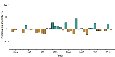
Precipitation anomaly in Badiar National Park -
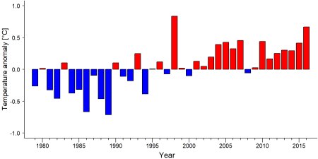
Temperature anomaly in Badiar National Park


External links
References
Bailo, D. S., et al. (2009). An inventory of biodiversity in the Badiar National Park, Guinea Conakry: Implications for conservation. Research Journal of Biological Sciences, 4(8), 948–951. link
BirdLife International. (2019). Important Bird Areas factsheet: Badiar. http://datazone.birdlife.org/site/factsheet/badiar-iba-guinea/text
Brugière, D., & Kormos, R. (2009). Review of the protected area network in Guinea, West Africa, and recommendations for new sites for biodiversity conservation. Biodiversity and Conservation, 18, 847. doi:10.1007/s10531-008-9508-z
Consulate of the Republic of Guinea. (n.d.). National park. https://www.consulateofguinea.com/national-park
GALF. (2012). Wildlife law enforcement in Guinea: March–November 2012 report. https://www.wara-enforcement.org/wp-content/uploads/2013/07/Report-GALF-march-nov-2012-Version-EN-.pdf
Ham, R. (1998). Nationwide chimpanzee census and large mammal survey, Republic of Guinea. Unpublished report for the European Communion, Guinea-Conakry.
Kiribou, R., Tehoda, P., Chukwu, O., Bempah, G., Kühl, H. S., Ferreira, J., …, & Heinicke, S. (2024). Exposure of African ape sites to climate change impacts. PLOS Climate, 3(2), e0000345. doi:10.1371/journal.pclm.0000345
METT. (2009). Management effectiveness evaluations: Parc National du Badiar. https://papaco.org/guinea/ link
Sambou, B., Goudiaby, A., Ervik, F., Diallo, D., & Camara, M. C. (2002). Palm wine harvesting by the Bassari threatens Borassus aethiopum populations in north-western Guinea. Biodiversity & Conservation, 11(7), 1149-1161. doi:10.1023/a:1016005025090
UNEP-WCMC, & IUCN. (2019). Protected Planet: The World Database on Protected Areas (WDPA). UNEP-WCMC and IUCN. https://www.protectedplanet.net/country/GN link
UNESCO MAB. (2011). UNESCO MAB biosphere reserve directory: Haut Niger. http://www.unesco.org/new/en/natural-sciences/environment/ecological-sciences/biosphere-reserves/africa/guinea/badiar/ link
Wild Chimpanzee Foundation. (2012). Etat de la faune et des menaces dans les aires protégées terrestres et principales zones de forte biodiversité de Rep. de Guinée. Wild Chimpanzee Foundation. http://www.wildchimps.org
Wild Chimpanzee Foundation. (2025, January). Annual report 2024: Activities of the Wild Chimpanzee Foundation for improved conservation of chimpanzees and their habitat in West Africa. https://www.wildchimps.org/fileadmin/content_files/pdfs/reports/2024_WCF_Annual_Report_2024_01.pdf link
Page created by: APES Atlas Team Date: 2019-05-29
Page updated by: Priscilla Stanley Shao Date: 2025-10-14