
Tala-Tala Forest Management Unit
Central Africa > Democratic Republic of the Congo > Tala-Tala Forest Management Unit
Français | Português | Español | Bahasa Indonesia | Melayu
Summary
- Central chimpanzees (Pan troglodytes troglodytes) & western lowland gorillas (Gorilla gorilla gorilla) are present in Tala-Tala Forest Management Unit.
- It has been estimated that 895 chimpanzees and 4,678 gorillas inhabit the site.
- The population trends are unknown.
Site characteristics
Table 1. Basic site information for Tala-Tala Forest Management Unit
| Species | Pan troglodytes troglodytes, Gorilla gorilla gorilla |
| Area | 6,167 km² |
| Coordinates | Lat: 1.8182 , Lon: 15.178 |
| Type of site | Logging concession |
| Habitat types | Subtropical/tropical dry forest, Subtropical/tropical swamp forest, Wetlands (lakes, rivers, streams, bogs, marshes) |
| Type of governance | Private governance |
Types of sites Governance types Habitat types
Ape status
Table 2. Ape population estimates reported for Tala-Tala Forest Management Unit
| Species | Year | Occurrence | Encounter or vistation rate (nests/km; ind/day) | Density estimate [ind./ km²] (95% CI) | Abundance estimate (95% CI) | Survey area | Sampling method | Analytical framework | Source | Comments | A.P.E.S. database ID |
|---|---|---|---|---|---|---|---|---|---|---|---|
| Pan troglodytes troglodytes | 2016-2018 | 0.48 | 0.15 (0.10-0.20) | 895 (638-1,256) | Tala-Tala Forest Management Unit | Line transects | Distance sampling with adopted decay time | Ngoran et al. (2019) | No nest decay study was conducted. The authors used nest decay rate from neighboring sites, leading to different numbers. The estimate given here are the conservative estimate | ||
| Gorilla gorilla gorilla | 2016-2018 | 1.18 | 0.76 (0.52-1.11) | 4,678 (3,202-6,835) | Tala-Tala Forest Management Unit | Line transects | Distance sampling with adopted decay time | Ngoran et al. (2019) | No nest decay study was conducted. The authors used nest decay rate from neighboring sites, leading to different numbers. The estimate given here are the conservative estimate |
Sampling methods Analytical frameworks
Threats
Table 3. Threats to apes reported for Tala-Tala Forest Management Unit
| Category | Specific threats | Threat level | Description | Year of threat |
|---|---|---|---|---|
| 11 Climate change & severe weather | 11.1 Habitat shifting & alteration | Medium (30-70% of population affected) | Unknown | |
| 2 Agriculture & aquaculture | 2.1.1 Shifting agriculture | Present (unknown severity) | This area plays a vital role in conserving elephants, great apes, and numerous other wildlife species. Despite significant human pressures such as hunting, agriculture, and logging, the Tala-Tala forest remains crucial for maintaining ecological connectivity within the TRIDOM landscape (Ngoran et al. 2019). | Ongoing (2019) |
| 5 Biological resource use | 5.1 Hunting & collecting terrestrial animals | High (more than 70% of population affected) | Although hunting signs are relatively high in the Tala-Tala forest, with an encounter rate of 0.55 signs/km, they account for only 15% of all human activity signs, which have an overall encounter rate of 3.62 signs/km (Ngoran et al. 2019). | 2015-Ongoing (2019) |
| 5 Biological resource use | 5.3.2 Commercial logging | Medium (30-70% of population affected) | Apart from specific hunting and logging activities, machete cuts and trails are frequently observed. The high abundance of machete cuts and trails highlights the significant presence of human activities throughout the Tala-Tala forest. Indeed, in carrying out various activities within the UFA Tala-Tala, trails are used to access desired locations. During movements along trails or off-trail, marks are often left on trees (Ngoran et al. 2019). | Ongoing (2019) |
Conservation activities
Challenges
Table 5. Challenges reported for Tala-Tala Forest Management Unit
| Challenges | Specific challenges | Source | Year(s) |
|---|---|---|---|
| Unknown |
Enablers
Research activities
Documented behaviours
Table 7. Behaviours documented for Tala-Tala Forest Management Unit
| Category | Behavior | Observation type | Prevalence | Observation dates | Source | Habituation | Species | Comment |
|---|---|---|---|---|---|---|---|---|
| Not reported |
Exposure to climate change impacts
As part of a study on the exposure of African great ape sites to climate change impacts, Kiribou et al. (2024) extracted climate data and data on projected extreme climate impact events for the site. Climatological characteristics were derived from observation-based climate data provided by the Inter-Sectoral Impact Model Intercomparison Project (ISIMIP, www.isimip.org). Parameters were calculated as the average across each 30-year period. For 1981-2010, the EWEMBI dataset from ISIMIP2a was used. For the two future periods (2021-2050 and 2071-2099) ISIMIP2b climate data based on four CMIP5 global climate models were used. For future projections, two Representative Concentration Pathways (RCP) were used. RCP 2.6 is a scenario with strong mitigation measures in which global temperatures would likely rise below 2C. RCP 6.0 is a scenario with medium emissions in which global temperatures would likely rise up to 3C by 2100. For the number of days with heavy precipitation events, the 98th percentile of all precipitation days (>1mm/d) was calculated for the 1979-2013 reference period as a threshold for a heavy precipitation event. Then, for each year, the number of days above that threshold was derived. The figures on temperature and precipitation anomaly show the deviation from the mean temperature and mean precipitation for the 1979-2013 reference period.
The estimated exposure to future extreme climate impact events (crop failure, drought, river flood, wildfire, tropical cyclone, and heatwave) is based on a published dataset by Lange et al. 2020 derived from ISIMIP2b data. The same global climate models and RCPs as described above were used. Within each 30-year period, the number of years with an extreme event and the average proportion of the site affected were calculated (Kiribou et al. 2024).
Table 8. Estimated past and projected climatological characteristics in Tala-Tala Forest Management Unit
| Value | 1981-2010 | 2021-2050, RCP 2.6 | 2021-2050, RCP 6.0 | 2071-2099, RCP 2.6 | 2071-2099, RCP 6.0 |
|---|---|---|---|---|---|
| Mean temperature [C] | 23.8 | 25.2 | 25 | 25.5 | 26.5 |
| Annual precipitation [mm] | 1573 | 1621 | 1613 | 1652 | 1618 |
| Max no. consecutive dry days (per year) | 18 | 11.8 | 13 | 11.8 | 12.4 |
| No. days with heavy precipitation (per year) | 6.6 | 7.7 | 8.5 | 8.7 | 9.3 |
Table 9. Projected exposure of apes to extreme climate impact events in Tala-Tala Forest Management Unit
| Type | No. of years with event (2021-2050, RCP 2.6) | % of site exposed (2021-2050, RCP 2.6) | No. of years with event (2021-2050, RCP 6.0) | % of site exposed (2021-2050, RCP 6.0) | No. of years with event (2070-2099, RCP 2.6) | % of site exposed (2070-2099, RCP 2.6) | No. of years with event (2070-2099, RCP 6.0) | % of site exposed (2070-2099, RCP 6.0) |
|---|---|---|---|---|---|---|---|---|
| Crop failure | 12 | 0.02 | 8.5 | 0.01 | 11.5 | 0 | 26.5 | 0.02 |
| Drought | 0 | 0 | 0 | 0 | 0 | 0 | 0.5 | 12.5 |
| Heatwave | 3 | 61.54 | 2 | 62.5 | 2.5 | 65.62 | 10 | 67.31 |
| River flood | 0.5 | 0.1 | 1.75 | 0.55 | 2 | 1.12 | 2.5 | 1.16 |
| Tropical cyclone | 0 | 0 | 0 | 0 | 0 | 0 | 0 | 0 |
| Wildfire | 30 | 0.43 | 30 | 0.49 | 29 | 0.4 | 29 | 0.39 |
-
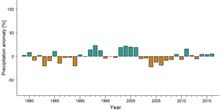
Precipitation anomaly in Tala-Tala Forest Management Unit -
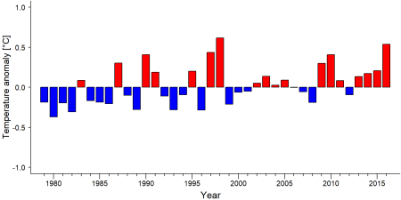
Temperature anomaly in Tala-Tala Forest Management Unit


External links
References
N'Goran, K. P., Allam, M. A., Yeno, L. S., Mahoungou, S., & Akenji, N. L. (2019). RAPPORT DE L’INVENTAIRE DES GRANDS ET MOYENS MAMMIFERES DANS L’UFA TALA-TALA. WWF & ETIC (Espace TRIDOM Interzone Congo) report.
Kiribou, R., Tehoda, P., Chukwu, O., Bempah, G., Kühl, H. S., Ferreira, J., …, & Heinicke, S. (2024). Exposure of African ape sites to climate change impacts. PLOS Climate, 3(2), e0000345. doi:10.1371/journal.pclm.0000345
Page created by: Tene Sop Date: 2024-11-27 10:33:00