
Wologizi Proposed Protected Area: Difference between revisions
No edit summary |
No edit summary |
||
| Line 14: | Line 14: | ||
* The following conservation activities were conducted byby the Skills and Agriculture Development Services (SADS) in villages near Wologizi: school-based environmental education program, community radio program, newspaper publication, discussions in villages, community forestry program. | * The following conservation activities were conducted byby the Skills and Agriculture Development Services (SADS) in villages near Wologizi: school-based environmental education program, community radio program, newspaper publication, discussions in villages, community forestry program. | ||
* Wologizi was removed from the list of proposed protected areas, as it appears to be important for iron ore (Johnson 2015); Wologizi is one of the ten most important conservation priority areas in terms of chimpanzee density, and large mammal and tree diversity (Junker et al. 2015). | * Wologizi was removed from the list of proposed protected areas, as it appears to be important for iron ore (Johnson 2015); Wologizi is one of the ten most important conservation priority areas in terms of chimpanzee density, and large mammal and tree diversity (Junker et al. 2015). | ||
= Site characteristics = | = Site characteristics = | ||
| Line 131: | Line 127: | ||
!Description | !Description | ||
!Year of threat | !Year of threat | ||
|- | |- | ||
|2 Agriculture & aquaculture | |2 Agriculture & aquaculture | ||
| Line 149: | Line 139: | ||
|Mining for gold diamonds (Johnson 2015). | |Mining for gold diamonds (Johnson 2015). | ||
|Ongoing (2015) | |Ongoing (2015) | ||
|- | |||
|5 Biological resource use | |||
|5.1.1 Subsistence bushmeat hunting | |||
|Low (up to 30% of population affected) | |||
|No specific data from Wologizi, but a common practice across the north-west of Liberia (Bamford pers. obs. 2024). | |||
|Ongoing (2024) | |||
|- | |- | ||
|5 Biological resource use | |5 Biological resource use | ||
| Line 157: | Line 153: | ||
|- | |- | ||
|5 Biological resource use | |5 Biological resource use | ||
|5. | |5.3.1 Subsistence logging | ||
| | |Medium (30-70% of population affected) | ||
| | |91.2 km2 (5.4% of total PPA area) of forest lost between 2000 and 2023, most after 2012 (Bamford pers. obs. 2024). | ||
| | |2000-2023 | ||
|} | |} | ||
Revision as of 10:50, 25 March 2026
West Africa > Liberia > Wologizi Proposed Protected Area
Français | Português | Español | Bahasa Indonesia | Melayu
Summary
- Western chimpanzees (Pan troglodytes verus) are present in Wologizi.
- The population size is unknown.
- The chimpanzee population trend is unknown.
- This site has a total size of 995 km².
- Key threats to chimpanzees are large-scale mining, commercial logging and poaching.
- The following conservation activities were conducted byby the Skills and Agriculture Development Services (SADS) in villages near Wologizi: school-based environmental education program, community radio program, newspaper publication, discussions in villages, community forestry program.
- Wologizi was removed from the list of proposed protected areas, as it appears to be important for iron ore (Johnson 2015); Wologizi is one of the ten most important conservation priority areas in terms of chimpanzee density, and large mammal and tree diversity (Junker et al. 2015).
Site characteristics
The main features of this area are the Wologizi Mountain Range and Wonegizi Mountains, (the Wonegizi Mountains form a transboundary conservation corridor between Liberia and the republic of Guinea and the biosphere reserve of Ziama) within two separate large blocks of largely uninhabited closed dense forest with rich biodiversity (Johnson 2015). The area includes Liberia’s highest mountain, Mount Wuteve (Wutuwi) at 1,447 m, as well as several other peaks, including Mount Balagizi (1,100 m). The mountains extend for 22 km with spurs reaching up to 5 km on either side of the ridge. Slopes on the ridge are exceedingly steep and in places form sheer cliffs up to 100 m high. With increasing altitude, tree-height decreases and the understorey becomes denser. Above 1,000 meters, areas of dense bush and grass are more common. The foothills and lower valleys are surrounded by large areas of savanna woodland (BirdLife International 2019). The area is an Important Bird Area (IBA), and includes important portions of the upper Lofa, Lawa, and Gbaye River watersheds. It is an important site for the endangered amphibian Phrynobatrachus annulatus. It is also the only known site in Liberia for the vulnerable amphibian Phrynobatrachus villiersii. Additionally, it is one of two sites in Liberia that contain the vulnerable Nimba flycatcher Melaenornis annamarulae and the white-necked picathartes Picathartes gymnocephalus. Also present are the zebra duiker Cephalophus zebra, pygmy hippopotamus Hexaprotodon liberiensis, leopard Panthera pardus, forest elephant Loxodonta africana (Johnson 2015), Upper Guinea red colobus Piliocolobus badius, Diana monkey Cercopithecus diana (Barrie et al. 2005), and bongo Tragelaphus euryceros (Junker unpubl. data). Wologizi is one of the ten most important conservation priority areas in terms of chimpanzee density, and large mammal and tree diversity (Junker et al. 2015).
Table 1. Basic site information for Wologizi Proposed Protected Area
| Species | Pan troglodytes verus |
| Area | 995 km² |
| Coordinates | Lat: 8.06 , Lon: -9.79 |
| Type of site | Proposed protected area |
| Habitat types | Subtropical/tropical moist lowland forest, Subtropical/tropical swamp forest, Subtropical/tropical moist montane forest, Wetlands (lakes, rivers, streams, bogs, marshes) |
| Type of governance |
Types of sites Governance types Habitat types
Ape status
The Rapid Assessment Survey conducted by FFI in 2005 (Barrie et al. 2005) confirmed the presence of chimpanzees in this area. The teams of the nationwide chimpanzee and large mammal survey (Tweh et al. 2014) also found direct (vocalization) and indirect signs of chimpanzee presence (nests, feeding sins) (Junker unpubl. data). A second Rapid Assessment Survey was conducted by FFI in collaboration with Elephant Research and Conservation (ELRECO) (Vogt pers. comm. 2019), again confirming the presence of chimpanzees in Wologizi. In addition, Johnson (2015) mentions that surveys were conducted in this area as part of the REDD Program; however, no further information regarding these surveys could be found.
Table 2. Ape population estimates reported for Wologizi Proposed Protected Area
| Species | Year | Occurrence | Encounter or vistation rate (nests/km; ind/day) | Density estimate [ind./ km²] (95% CI) | Abundance estimate (95% CI) | Survey area | Sampling method | Analytical framework | Source | Comments | A.P.E.S. database ID |
|---|---|---|---|---|---|---|---|---|---|---|---|
| Pan troglodytes verus | 2023 | Present | Wologizi | Camera trap | Fauna & Flora | Chimps only found at higher elevations. | |||||
| Pan troglodytes verus | 2010 | Present | Wologizi (south-western boundary) | Line transects & recces | Junker unpubl. data | ‘reconnaissance walk’, as part of the nationwide chimpanzee and large mammal survey (Tweh et al. 2014) | |||||
| Pan troglodytes verus | 2005 | Present | Wologizi (North Lorma National Forest) | Reconnaissance walk | FFI Rapid Assessment Survey | ||||||
| Pan troglodytes verus | 2018-2019 | Present | Wologizi | Reconnaissance walk | FFI Rapid Assessment Survey |
Sampling methods Analytical frameworks
Threats
A considerable part of the proposed protected area is covered by Mineral Exploration Licenses (MEL) for gold and diamonds owned by Noya Mining Ltd. (Johnson 2015). MEL’s entail that after a proposed exploration program has been handed to the Minister of Land, Mines, and Energy, the company commences exploration (Wilson et al. 2017). Barrie et al. (2005) mention logging and poaching as additional threats to wildlife in this area. Wologizi used to overlap with illegally issued Private-Use Permits (PUP) for commercial logging. Private Use Permits were a type of logging licence designed to allow private landowners to cut trees on their property, but which were reportedly subject to misuse by commercial logging companies. After investigations by Global Witness (Global Witness 2013) much public outcry and extensive media coverage, PUPs have now largely been rescinded (Johnson 2015). The nationwide teams found signs of small-scale logging and poaching on recces/line transects near the north-eastern and south-western boundary of Wologizi (Junker unpubl. data). However, they also recorded taboos against the killing and/or eating of chimpanzees in villages in the same area (Junker unpubl. data).
Table 3. Threats to apes reported for Wologizi Proposed Protected Area
| Category | Specific threats | Threat level | Description | Year of threat |
|---|---|---|---|---|
| 2 Agriculture & aquaculture | 2.1 Annual & perennial non-timber crops | Low (up to 30% of population affected) | Small-holder rice fields and other plantations observed (Junker unpubl. data). | Ongoing (2011) |
| 3 Energy production & mining | 3.2 Mining & quarrying | High (more than 70% of population affected) | Mining for gold diamonds (Johnson 2015). | Ongoing (2015) |
| 5 Biological resource use | 5.1.1 Subsistence bushmeat hunting | Low (up to 30% of population affected) | No specific data from Wologizi, but a common practice across the north-west of Liberia (Bamford pers. obs. 2024). | Ongoing (2024) |
| 5 Biological resource use | 5.3 Logging & wood harvesting | Medium (30-70% of population affected) | Evidence of logging activities (Barrie et al. 2005); area overlapped with PUPs, which have been withdrawn (Johnson 2015, Junker et al. 2015). | Ongoing (2015) |
| 5 Biological resource use | 5.3.1 Subsistence logging | Medium (30-70% of population affected) | 91.2 km2 (5.4% of total PPA area) of forest lost between 2000 and 2023, most after 2012 (Bamford pers. obs. 2024). | 2000-2023 |
Conservation activities
The work of the Skills and Agriculture Development Services (SADS) focuses on promoting environmental conservation, sustainable forest management and alternative livelihood provision, as means of generating incomes to support their lifestyle (Johnson 2015). In May 2010, SADS, in collaboration with Conservation International (CI) has launched The Green Forum Program, which includes a community radio program, a newspaper publication, a school-based environmental education program, and a community forestry program.The purpose of The Green Forum is to set a stage for the exchange of ideas and information on current environmental issues of relevance in Liberia in order to raise public awareness and lay the framework for informed engagement (SADS 2010).
Table 4. Conservation activities reported for Wologizi Proposed Protected Area
| Category | Specific activity | Description | Implementing organization(s) | Year of activity |
|---|---|---|---|---|
| 2 Counter-wildlife crime | 2.11 Implement monitoring surveillance strategies (e.g., SMART) or use monitoring data to improve effectiveness of patrols | Bamford pers. comm. 2024 | Ongoing (2024) | |
| 2 Counter-wildlife crime | 2.12 Implement community control of patrolling, banning hunting and removing snares | Bamford pers. comm. 2024 | Ongoing (2024) | |
| 2 Counter-wildlife crime | 2.13 Provide sustainable alternative livelihoods; establish fish- or domestic meat farms | Bamford pers. comm. 2024 | Ongoing (2024) | |
| 2 Counter-wildlife crime | 2.6 Regularly de-activate/remove ground snares | Bamford pers. comm. 2024 | Ongoing (2024) | |
| 4 Education & awareness | 4.1 Educate local communities about apes and sustainable use | School-based environmental education program (SADS 2010) – not specifically targeted at chimpanzee/primate conservation | 2010 | |
| 4 Education & awareness | 4.2 Involve local community in ape research and conservation management | Bamford pers. comm. 2024 | Ongoing (2024) | |
| 4 Education & awareness | 4.4 Regularly play TV and radio announcements to raise ape conservation awareness | Community radio program (SADS 2010) – not specifically targeted at chimpanzee/primate conservation | 2010 | |
| 4 Education & awareness | 4.5 Implement multimedia campaigns using theatre, film, print media, discussions | Newspaper publication, discussions in villages near Wologizi (SADS 2010) – not specifically targeted at chimpanzee/primate conservation | 2010 | |
| 5 Protection & restoration | 5.2 Legally protect ape habitat | Bamford pers. comm. 2024 | Ongoing (2024) | |
| 5 Protection & restoration | 5.5 Demarcate and enforce boundaries of protected areas | Bamford pers. comm. 2024 | Ongoing (2024) | |
| 8 Permanent presence | 8.3 Permanent presence of staff/manager | Bamford pers. comm. 2024 | Ongoing (2024) |
Challenges
Table 5. Challenges reported for Wologizi Proposed Protected Area
| Challenges | Specific challenges | Source | Year(s) |
|---|---|---|---|
| Not reported |
Enablers
Table 6. Enablers reported for Wologizi Proposed Protected Area
| Enablers | Specific enablers | Source | Year(s) |
|---|---|---|---|
| 1 Site management | |||
| 2 Resources and capacity | |||
| 3 Engaged community | |||
| 4 Institutional support | |||
| 5 Ecological context | |||
| 6 Safety and stability |
Research activities
Documented behaviours
Signs of chimpanzee nut cracking observed during Rapid Assessment Survey (Barrie et al. 2005).
Table 7. Behaviours documented for Wologizi Proposed Protected Area
| Category | Behavior | Observation type | Prevalence | Observation dates | Source | Habituation | Species | Comment |
|---|---|---|---|---|---|---|---|---|
| Nut cracking | Barrie et al. 2005 | |||||||
| Not reported |
Exposure to climate change impacts
As part of a study on the exposure of African great ape sites to climate change impacts, Kiribou et al. subm. extracted climate data and data on projected extreme climate impact events for the site. Climatological characteristics were derived from observation-based climate data provided by the Inter-Sectoral Impact Model Intercomparison Project (ISIMIP, www.isimip.org). Parameters were calculated as the average across each 30-year period. For 1981-2010, the EWEMBI dataset from ISIMIP2a was used. For the two future periods (2021-2050 and 2071-2099) ISIMIP2b climate data based on four CMIP5 global climate models were used. For future projections, two Representative Concentration Pathways (RCP) were used. RCP 2.6 is a scenario with strong mitigation measures in which global temperatures would likely rise below 2C. RCP 6.0 is a scenario with medium emissions in which global temperatures would likely rise up to 3C by 2100. For the number of days with heavy precipitation events, the 98th percentile of all precipitation days (>1mm/d) was calculated for the 1979-2013 reference period as a threshold for a heavy precipitation event. Then, for each year, the number of days above that threshold was derived. The figures on temperature and precipitation anomaly show the deviation from the mean temperature and mean precipitation for the 1979-2013 reference period.
The estimated exposure to future extreme climate impact events (crop failure, drought, river flood, wildfire, tropical cyclone, and heatwave) is based on a published dataset by Lange et al. 2020 derived from ISIMIP2b data. The same global climate models and RCPs as described above were used. Within each 30-year period, the number of years with an extreme event and the average proportion of the site affected were calculated (see Kiribou et al. subm. for details).
Table 8. Estimated past and projected climatological characteristics in Wologizi Proposed Protected Area
| Value | 1981-2010 | 2021-2050, RCP 2.6 | 2021-2050, RCP 6.0 | 2071-2099, RCP 2.6 | 2071-2099, RCP 6.0 |
|---|---|---|---|---|---|
| Mean temperature [C] | 24.6 | 25.8 | 25.7 | 25.8 | 27 |
| Annual precipitation [mm] | 2639 | 2668 | 2715 | 2752 | 2843 |
| Max no. consecutive dry days (per year) | 27.6 | 30.9 | 30 | 31.1 | 35.1 |
| No. days with heavy precipitation (per year) | 6.4 | 7.3 | 7.4 | 7.3 | 8.5 |
Table 9. Projected exposure of apes to extreme climate impact events in Wologizi Proposed Protected Area
| Type | No. of years with event (2021-2050, RCP 2.6) | % of site exposed (2021-2050, RCP 2.6) | No. of years with event (2021-2050, RCP 6.0) | % of site exposed (2021-2050, RCP 6.0) | No. of years with event (2070-2099, RCP 2.6) | % of site exposed (2070-2099, RCP 2.6) | No. of years with event (2070-2099, RCP 6.0) | % of site exposed (2070-2099, RCP 6.0) |
|---|---|---|---|---|---|---|---|---|
| Crop failure | 5.5 | 0.04 | 5 | 0.05 | 3.5 | 0.04 | 8.5 | 0.05 |
| Drought | 0 | 0 | 0 | 0 | 0 | 0 | 0 | 0 |
| Heatwave | 11 | 100 | 6.5 | 100 | 11 | 100 | 9.5 | 100 |
| River flood | 1.5 | 0.83 | 1.5 | 0.6 | 1.5 | 2.7 | 4 | 1.42 |
| Tropical cyclone | 0 | 0 | 0 | 0 | 0 | 0 | 0 | 0 |
| Wildfire | 30 | 0.7 | 30 | 0.71 | 29 | 0.72 | 29 | 0.74 |
-
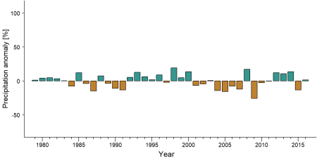
Precipitation anomaly in Wologizi Proposed Protected Area -
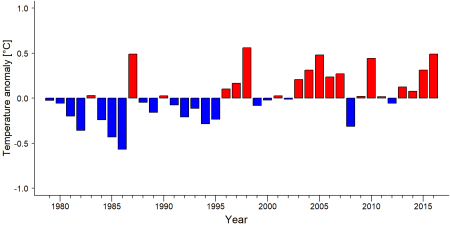
Temperature anomaly in Wologizi Proposed Protected Area


External links
References
BirdLife International 2019. Important Bird Areas factsheet: Wologizi mountains. Downloaded from http://www.birdlife.org on 04/11/2019.
Global Witness. (2013). Avoiding the Riptide: Liberia must Enforce its Forest Laws to Prevent a New Wave of Illegal and Destructive Logging Contracts. Global Witness.
Johnson S. 2015. Aggregated Biodiversity Offsets: A Roadmap for Liberia’s Mining Sector. Unpublished report by the World Bank Group (WBG) and Program On Forests (PROFOR).
Junker J, Boesch C, Freeman T, Mundry R, Stephens C, Kühl HS. 2015. Integrating wildlife conservation with conflicting economic land-use goals in a West African biodiversity hotspot. Basic and Applied Ecology: doi:10.1016/j.baae.2015.07.002.
Skills and Agricultural Development Services (SADS) 2010. Annual Report. Unpublished report.
Tweh C, Lormie M, Kouakou CY, Hillers A, Kühl HS, Junker J, et al. 2014. Conservation status of chimpanzees Pan troglodytes verus and other large mammals in Liberia: a nationwide survey. Oryx: http://dx.doi.org/10.1017/S0030605313001191.
Wilson STK, Wang H, Kabenge M, Qi X. 2017. The mining sector of Liberia: current practices and environmental challenges. Environmental Science and Pollution Research 24: 18711–18720.
Page created by: Andrew Bamford Date: 2024-09-05