
Ziama Biosphere Reserve: Difference between revisions
No edit summary |
No edit summary |
||
| Line 89: | Line 89: | ||
|[[#R01979|WCF 2012]] | |[[#R01979|WCF 2012]] | ||
|Total survey effort: 157 km, encounter rate was too low to estimate total abundance, the value given is an approximation | |Total survey effort: 157 km, encounter rate was too low to estimate total abundance, the value given is an approximation | ||
|GIN0002, GIN0010 | |GIN0002, GIN0010<div class="mw-collapsible mw-collapsed" data-expandtext="+9 more" data-collapsetext="less">GIN0016, GIN0020, GIN0023, GIN0024, GIN0025, GIN0027, GIN0029, GIN0036, GIN0069</div> | ||
|- | |- | ||
|''Pan troglodytes verus'' | |''Pan troglodytes verus'' | ||
Revision as of 15:13, 14 October 2026
West Africa > Republic of Guinea > Ziama Biosphere Reserve
Français | Português | Español | Bahasa Indonesia | Melayu
Summary
- Western chimpanzees (Pan troglodytes verus) are present in Ziama Biosphere Reserve.
- It has been estimated that less than 20 chimpanzees occur at the site.
- The chimpanzee population trend is stable.
- This site has a total size of 1,162 km².
- Key threats to chimpanzees are hunting, agricultural activities, roads and deforestation.
- The following conservation activities are ongoing: law enforcement, bio-monitoring and reducing illegal agricultural activities.
- Ziama Biosphere Reserve has the last population of forest elephants in Guinea.
Site characteristics
Ziama Biosphere Reserve (also called Massif du Ziama, Ziama Classified Forest) is located in southern Guinea and is contiguous with Wonegizi Nature Reserve in Liberia (UNEP-WCMC and IUCN 2018). It is designated a Classified Forest (IUCN category not reported, UNEP-WCMC and IUCN 2018) and is a UNESCO Biosphere Reserve since 1980 (UNESCO MAB 2007). The forest is located in Guinée forestière, one of four Guinean natural regions, and is part of the region N'Zérékoré. Ziama massif is part of the Guinea Highlands and the altitude of the area ranges from 500 to 1,387 m (UNESCO MAB 2007). Due to its diverse topographic features, including mountains, valleys and plateaus, Ziama forest features different habitat types: primary mountain forests, secondary mountain forests, and secondary lowland forest, swamps and savannas (UNESCO MAB 2007). The terrain is very rugged and annual rainfall ranges from 1,700 to 2,000 mm (BirdLife International 2018).
In a conservation priority setting workshop in 2001, Ziama forest was identified as one of the most important areas for biodiversity conservation between Guinea and Togo (Bakarr et al. 2001). One of its most notable features is that its forest elephant (Loxodonta africana) population is the last population in Guinea ([forestelephants.org/phase-two-ziama/ AFEF 2017]). With its 287 bird species, Ziama is also an Important Bird Area (BirdLife International 2018). Furthermore, it harbors 31 bat species, 54 reptile species, 30 amphibian species as well as more than 1,300 plant species (WCF 2012). Together with Diéké Classified Forest, Ziama Biosphere Reserve is one of the last remaining large forest blocks in southern Guinea.
Ziama forest has a total size of 1,161.70 km² and is divided into three management areas: a core area of 425.4 km², a buffer zone of 272.3 km², and a transition area of 463.9 km² (Brugiere & Kormos 2009). It is about 40 km from the town of Macenta (BirdLife International 2018), and 100 km from the city of N’Zérékoré (UNESCO MAB 2007). According to a survey from 1980, around 29,000 people live within the biosphere reserve (UNESCO MAB 2007). There is also a forestry concession of 300 km² in the transition zone with a forestry station and chipboard production (UNESCO MAB 2007), as well as a palm grove (WCF 2012).
Table 1. Basic site information for Ziama Biosphere Reserve
| Species | Pan troglodytes verus |
| Area | 1,162 km² |
| Coordinates | Lat: 8.28 , Lon: -9.34 |
| Type of site | Protected area (Classified Forest) |
| Habitat types | Subtropical/tropical moist montane forest, Subtropical/tropical moist lowland forest, Savanna, Wetlands (lakes, rivers, streams, bogs, marshes), Agricultural land |
| Type of governance | Shared governance |
Types of sites Governance types Habitat types
Ape status
Based on a nation-wide questionnaire survey, the presence of western chimpanzees was confirmed by Sugiyama & Soumah (1988). In a nationwide survey Rebecca Kormos identified Ziama Biosphere Reserve as the second most important priority area for western chimpanzee conservation in Guinea due to high chimpanzee densities encountered during reconnaissance surveys (Ham 1998). However, a recent nationwide survey by the Wild Chimpanzee Foundation found very low densities of chimpanzee signs and was therefore not able to estimate total chimpanzee abundance (WCF 2012). WCF concluded that less than 20 individuals remain and are restricted to high altitude areas that are unsuitable for agriculture (2012).
Table 2. Ape population estimates reported for Ziama Biosphere Reserve
| Species | Year | Occurrence | Encounter or vistation rate (nests/km; ind/day) | Density estimate [ind./ km²] (95% CI) | Abundance estimate (95% CI) | Survey area | Sampling method | Analytical framework | Source | Comments | A.P.E.S. database ID |
|---|---|---|---|---|---|---|---|---|---|---|---|
| Pan troglodytes verus | 2016 | Ziama forest | Reconnaissance walk | FFI | |||||||
| Pan troglodytes verus | 2012 | 0.04 | 20.0 | Ziama forest | Line transects | WCF 2012 | Total survey effort: 157 km, encounter rate was too low to estimate total abundance, the value given is an approximation | GIN0002, GIN0010 GIN0016, GIN0020, GIN0023, GIN0024, GIN0025, GIN0027, GIN0029, GIN0036, GIN0069
| |||
| Pan troglodytes verus | 1997 | Ziama forest | Reconnaissance walk | Ham 1998 | Reconnaissance survey | GIN0019, GIN0021 | |||||
| Pan troglodytes verus | 1988 | Present | 50.0 | Ziama forest | Interviews | Sugiyama & Soumah 1988 | Questionnaire survey |
Sampling methods Analytical frameworks
Threats
Ziama forest was shown to have a high prevalence of anthropogenic pressures (WCF 2012). Already in the 1990s hunting was recognized as a major threat to chimpanzees (Ham 1998) and during their recent survey of the area WCF also found a very high density of hunting signs (WCF 2012). A survey by FFI in 2016 revealed that illegal agricultural activities in wetlands, i.e., bas-fonds farming, led to large-scale forest fragmentation (FFI 2018). Threats are especially prevalent along the northern forest border where several villages and roads can be found (WCF 2012). This is also where a major road connecting the urban centres of Macenta and N’Zérékoré passes through, resulting in high rates of deforestation and hunting in the two northern forest enclaves (WCF 2012). The two southern forest enclaves close to the border with Liberia had been the scene of territorial conflicts during the war in Liberia, which led to the serious degradation of the forest (WCF 2012).
Table 3. Threats to apes reported for Ziama Biosphere Reserve
| Category | Specific threats | Threat level | Description | Year of threat |
|---|---|---|---|---|
| 1 Residential & commercial development | 1.1 Residential areas | Medium (30-70% of population affected) | Recent expansion of village settlements (WCF 2012). | 2005-Ongoing (2012) |
| 2 Agriculture & aquaculture | 2.1 Annual & perennial non-timber crops | High (more than 70% of population affected) | Illegal agriculture across large areas of the forest (WCF 2012, Estela pers. comm. 2022), especially bas-fonds farming in wetlands (FFI 2018). | 2012-Ongoing (2022) |
| 4 Transportation & service corridors | 4.1 Roads & railroads | Medium (30-70% of population affected) | Recent extension of roads around villages in the North (WCF 2012). National road crosses the PA, as well as roads that connect enclaves to the national road (Estela, N. pers. Comm. 2022). | Ongoing (2022) |
| 5 Biological resource use | 5.1 Hunting & collecting terrestrial animals | High (more than 70% of population affected) | Hunting consistently mentioned as a major threat (Ham 1998, WCF 2012, Estela pers. comm. 2022). | 1998-Ongoing (2022) |
| 5 Biological resource use | 5.1.2 Unintentional effects | Present (unknown severity) | Great apes injured by traps probably intended for other animals (APES Atlas team pers. comm. 2025). | Ongoing (2025) |
| 5 Biological resource use | 5.1.5 Persecution/human wildlife conflict | Present (unknown severity) | Human wildlife conflict has been reported, with interactions between humans and great apes leading to various challenges, including crop raiding by great apes, people feeling unsafe around them, shared use of water sources and wild natural resources such as forest fruits, unexpected encounters on paths or trails, and, in some cases, the killing of great apes for trade or cultural reasons (APES Atlas team pers. comm. 2025). | Ongoing (2025) |
| 5 Biological resource use | 5.3 Logging & wood harvesting | Medium (30-70% of population affected) | Deforestation especially prevent in the North [10], territorial conflict during the Liberian war resulted in forest degradation in the South (WCF 2012). | Ongoing (2012) |
| 8 Invasive & other problematic species, genes & diseases | 8.4 Pathogens | Present (unknown severity) | A potential risk of disease transmission between humans and apes was reported (APES Atlas team pers. comm. 2025). | Ongoing (2025) |
| 9 Pollution | 9.3 Agricultural & forestry effluents | Present (unknown severity) | Use of herbicides and pesticides in the wetlands under agriculture in the buffer zone (Estela, N. pers. Comm. 2022). | Ongoing (2022) |
Conservation activities
The Centre Forestier de N'Zérékore, attached to the Ministry of the Environment and Sustainable Development, is the management authority of Ziama MAB. Partners like UNOPS and Fauna & Flora International have been supporting CFZ to develop baseline for the protected area, the management plan and the implementation of management activities since 2016 (Estela, N. pers. Comm. 2022). In the 1990’s the forest was divided into three land-use zones, the outer two allowing for different degrees of human activities, while the core of the forest was designated an ‘integrally protected area’ (METT 2009). From 1994 until 2008 the work of the park authorities was financially supported by the World Bank and the KfW as part of the PROGERFOR project (METT 20019). Since 2009 Fauna & Flora International (FFI) supports the work of park authorities as part of the FFI transboundary project with Wonegizi proposed protected area in Liberia. Specifically FFI supports law enforcement and biomonitoring, and works with farmers to encourage a transition from bas-fonds agriculture in wetlands to using land close to the villages and outside of the forest. FFI also started developing a management plan (FFI 2018). The African Forest Elephant Foundation (AFEF) is fundraising for better equipment for rangers from forest authorities that are protecting forest elephants (AFEF 2017).
Table 4. Conservation activities reported for Ziama Biosphere Reserve
| Category | Specific activity | Description | Implementing organization(s) | Year of activity |
|---|---|---|---|---|
| 1 Development impact mitigation | 1.4 Farm more intensively and effectively in selected areas and spare more natural land | FFI works with local farmers to encourage them to use land around villages and outside of the forest for farming instead wetlands (FFI 2018) | Ongoing (2018) | |
| 2 Counter-wildlife crime | 2.11 Implement monitoring surveillance strategies (e.g., SMART) or use monitoring data to improve effectiveness of patrols | CFZ in Ziama has a SMART database and produces monthly reports to improve the effectiveness of the law enforcement since 2019 (Estela, N. pers. Comm. 2022). | 2019-Ongoing (2022) | |
| 2 Counter-wildlife crime | 2.12 Implement community control of patrolling, banning hunting and removing snares | Community auxiliaries take part of the reconnaissance patrols with CFZ rangers and report back to the community about the findings (Estela, N. pers. Comm. 2022). | Ongoing (2022) | |
| 2 Counter-wildlife crime | 2.13 Provide sustainable alternative livelihoods; establish fish- or domestic meat farms | Developing an environmental feasibility study on fish farming (Estela, N. pers. Comm. 2022). | Ongoing (2022) | |
| 2 Counter-wildlife crime | 2.3 Conduct regular anti-poaching patrols | The Centre Forestière de N’Zérékoré conducts anti-poaching patrols and is supported by FFI (FFI 2018). Patrols and law enforcement activities were reported again in 2025 (APES Atlas team pers. comm. 2025). | 2018-Ongoing (2025) | |
| 2 Counter-wildlife crime | 2.6 Regularly de-activate/remove ground snares | Biomonitoring and anti-poaching patrols by rangers of the Centre Forestier de N'Zérékoré's, the management authority (Estela, N. pers. Comm. 2022). | Ongoing (2022) | |
| 2 Counter-wildlife crime | 2.7 Provide better equipment (e.g., guns) to anti-poaching ranger patrols | AFEF is fundraising to provide rangers with boots (AFEF 2017) | Ongoing (2017) | |
| 2 Counter-wildlife crime | 2.8 Provide training to anti-poaching ranger patrols | Training on SMART, GPS use, prosecution processes, social safeguards (Estela, N. pers. Comm. 2022). | Ongoing (2022) | |
| 4 Education & awareness | 4.1 Educate local communities about apes and sustainable use | Awareness-raising activities, such as teaching people about great apes, are reported (APES Atlas team pers. comm. 2025). | Ongoing (2025) | |
| 4 Education & awareness | 4.2 Involve local community in ape research and conservation management | Local communities are involved in conservation through the establishment of local governance committees in riverside villages, with participation in decision-making meetings such as CoCoSi and CCO (APES Atlas team pers. comm. 2025). | Ongoing (2025) | |
| 4 Education & awareness | 4.3 Install billboards to raise ape conservation awareness | Billboards of protected species in the main villages of Ziama (Estela, N. pers. Comm. 2022). | Ongoing (2022) | |
| 5 Protection & restoration | 5.1 Create buffer zones around protected ape habitat | Forest was divided into three land-use zones, with the core of the forest being designated as an Integrally Protected Area (METT 2009) | Unknown | |
| 5 Protection & restoration | 5.2 Legally protect ape habitat | Designated as Classified Forest (UNEP-WCMC and IUCN 2018) | 1932-Ongoing (2026) | |
| 5 Protection & restoration | 5.5 Demarcate and enforce boundaries of protected areas | CFZ rangers and communities are currently defining the limits of the PA, given they were not clear on the ground, and it created conflicts between rangers and people from communities (Estela, N. pers. Comm. 2022). | Ongoing (2022) | |
| 5 Protection & restoration | 5.6 Habitat restoration | Replanting activities by park authorities (METT 2009). Forest rehabillitation and protection activities were also reported (APES Atlas team pers. comm. 2025). | 2008, 2009-Ongoing (2025) | |
| 5 Protection & restoration | 5.8 Restrict number of people that are allowed access to site | Core zones are restricted, only CFZ rangers or researchers can access. The buffer zone allows some activities that will be regulated by co-management as stated in the Management Plan (Estela, N. pers. Comm. 2022). | Ongoing (2022) | |
| 7 Economic & other incentives | 7.1 Provide monetary benefits to local communities for sustainably managing their forest and its wildlife (e.g., REDD, alternative income, employment) | Local people are employed in conservation projects (APES Atlas team pers. comm. 2025). | Ongoing (2025) | |
| 7 Economic & other incentives | 7.2 Provide non-monetary benefits to local communities for sustainably managing their forest and its wildlife (e.g., better education, infrastructure development) | Local communities are supported in developing ecotourism, creating alternative income sources such as selling local products, and managing their own forests (APES Atlas team pers. comm. 2025). | Ongoing (2025) | |
| 8 Permanent presence | 8.3 Permanent presence of staff/manager | About 50 CFZ rangers based in Ziama and 10 FFI staff focused on supporting the effective management of the PA (Estela, N. pers. Comm. 2022). | Ongoing (2022) |
Challenges
Table 5. Challenges reported for Ziama Biosphere Reserve
| Challenges | Specific challenges | Source | Year(s) |
|---|---|---|---|
| 2 Resources and capacity | 2.1 Lack of capacity/training | METT 2009 | 2009-Ongoing (2025) |
| 2 Resources and capacity | 2.1 Sufficient staff | APES Atlas team pers. comm. 2025 | Ongoing (2025) |
| 2 Resources and capacity | 2.3 Continuous/long-term funding | APES Atlas team pers. comm. 2025 | Ongoing (2025) |
| 2 Resources and capacity | 2.3 General lack of funding | METT 2009 | 2009-Ongoing (2025) |
| 2 Resources and capacity | 2.5 Lack of equipment/transportation | METT 2009 |
Enablers
Table 6. Enablers reported for Ziama Biosphere Reserve
| Enablers | Specific enablers | Source | Year(s) |
|---|---|---|---|
| 2 Resources and capacity | 2.6 External partnerships that add expertise or resources | APES Atlas team pers. comm. 2025 | Ongoing (2025) |
| 3 Engaged community | 3.6 Local community engagement and support | APES Atlas team pers. comm. 2025 | Ongoing (2025) |
| 1 Site management | |||
| 4 Institutional support | |||
| 5 Ecological context | |||
| 6 Safety and stability |
Research activities
From 1996 to 1997 Rebecca Kormos (née Ham) did a nationwide survey on chimpanzees across Guinea (Ham 1998), and identified Ziama Biosphere Reserve as a priority site. To inform the extension of the protected area network Brugière and Kormos (2009) identified 16 Key Biodiversity Areas across Guinea based on the occurrence of globally threatened large and medium-sized mammals, among which Ziama Classified Forest ranked first. The Wild Chimpanzee Foundation did a nationwide inventory of chimpanzee populations in Guinea between 2009 and 2011. The WCF monitoring team covered a total of 10 sites, including Ziama Biosphere Reserve, using transect surveys (WCF 2012). In 2016 FFI conducted a biomonitoring and threat monitoring study in Ziama (FFI 2018).
Documented behaviours
Table 7. Behaviours documented for Ziama Biosphere Reserve
| Category | Behavior | Observation type | Prevalence | Observation dates | Source | Habituation | Species | Comment |
|---|---|---|---|---|---|---|---|---|
| Not reported |
Exposure to climate change impacts
As part of a study on the exposure of African great ape sites to climate change impacts, Kiribou et al. (2024) extracted climate data and data on projected extreme climate impact events for the site. Climatological characteristics were derived from observation-based climate data provided by the Inter-Sectoral Impact Model Intercomparison Project (ISIMIP, www.isimip.org). Parameters were calculated as the average across each 30-year period. For 1981-2010, the EWEMBI dataset from ISIMIP2a was used. For the two future periods (2021-2050 and 2071-2099) ISIMIP2b climate data based on four CMIP5 global climate models were used. For future projections, two Representative Concentration Pathways (RCP) were used. RCP 2.6 is a scenario with strong mitigation measures in which global temperatures would likely rise below 2C. RCP 6.0 is a scenario with medium emissions in which global temperatures would likely rise up to 3C by 2100. For the number of days with heavy precipitation events, the 98th percentile of all precipitation days (>1mm/d) was calculated for the 1979-2013 reference period as a threshold for a heavy precipitation event. Then, for each year, the number of days above that threshold was derived. The figures on temperature and precipitation anomaly show the deviation from the mean temperature and mean precipitation for the 1979-2013 reference period.
The estimated exposure to future extreme climate impact events (crop failure, drought, river flood, wildfire, tropical cyclone, and heatwave) is based on a published dataset by Lange et al. 2020 derived from ISIMIP2b data. The same global climate models and RCPs as described above were used. Within each 30-year period, the number of years with an extreme event and the average proportion of the site affected were calculated (Kiribou et al. 2024).
Table 8. Estimated past and projected climatological characteristics in Ziama Biosphere Reserve
| Value | 1981-2010 | 2021-2050, RCP 2.6 | 2021-2050, RCP 6.0 | 2071-2099, RCP 2.6 | 2071-2099, RCP 6.0 |
|---|---|---|---|---|---|
| Mean temperature [C] | 24.3 | 25.5 | 25.4 | 25.5 | 26.7 |
| Annual precipitation [mm] | 2448 | 2482 | 2522 | 2553 | 2646 |
| Max no. consecutive dry days (per year) | 29.9 | 31.2 | 30.5 | 32.3 | 35.7 |
| No. days with heavy precipitation (per year) | 6.2 | 8.6 | 7.7 | 8.6 | 9.9 |
Table 9. Projected exposure of apes to extreme climate impact events in Ziama Biosphere Reserve
| Type | No. of years with event (2021-2050, RCP 2.6) | % of site exposed (2021-2050, RCP 2.6) | No. of years with event (2021-2050, RCP 6.0) | % of site exposed (2021-2050, RCP 6.0) | No. of years with event (2070-2099, RCP 2.6) | % of site exposed (2070-2099, RCP 2.6) | No. of years with event (2070-2099, RCP 6.0) | % of site exposed (2070-2099, RCP 6.0) |
|---|---|---|---|---|---|---|---|---|
| Crop failure | 5.5 | 1.66 | 5.5 | 1.66 | 4.5 | 1.66 | 7 | 1.66 |
| Drought | 0 | 0 | 0 | 0 | 0 | 0 | 0 | 0 |
| Heatwave | 6 | 100 | 6.5 | 100 | 8.5 | 100 | 8.5 | 100 |
| River flood | 0.5 | 0.85 | 1 | 3.21 | 1.5 | 3.39 | 4 | 1.95 |
| Tropical cyclone | 0 | 0 | 0 | 0 | 0 | 0 | 0 | 0 |
| Wildfire | 30 | 0.6 | 30 | 0.6 | 29 | 0.59 | 29 | 0.61 |
-
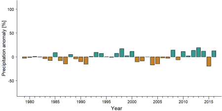
Precipitation anomaly in Ziama Biosphere Reserve -
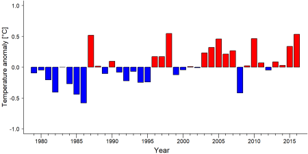
Temperature anomaly in Ziama Biosphere Reserve


External links
References
AFEF. 2017. African Forest Elephant Foundation. Phase Two – Ziama (Guinea). Online: [forestelephants.org/phase-two-ziama/ forestelephants.org] link
Bakarr M et al. 2001. in IUCN 2008. From forest to the sea: biodiversity connections from Guinea to Togo. Conservation priority setting workshop. Washington D.C., USA: Conservation International
BirdLife International. 2018. Important Bird Areas factsheet: Massif du Ziama. Online: www.birdlife.org
Brugière D, Kormos R. 2009. Review of the protected area network in Guinea, West Africa, and recommendations for new sites for biodiversity conservation, Biodiversity and Conservation, 18:847 doi:10.1007/s10531-008-9508-z
FFI. 2018. Fauna & Flora International . Supporting effective management of Ziama Man and Biosphere Reserve. Online: [www.fauna-flora.org/projects/supporting-effective-management-ziama-man-biosphere-reserve www.fauna-flora.org]
Ham R. 1998. Nationwide chimpanzee census and large mammal survey Republic of Guinea
METT. 2009. Management Effectiveness Evaluations – Forêt Classée de Ziama. Online: papaco.org link
Sugiyama, Y., & Soumah, A. G. (1988). Preliminary survey of the distribution and population of chimpanzees in the Republic of Guinea. Primates, 29(4), 569-574. doi:10.1007/bf02381144
UNEP-WCMC, IUCN. 2018. Protected Planet: The World Database on Protected Areas (WDPA), Cambridge, UK: UNEP-WCMC and IUCN Online: www.protectedplanet.net link
UNESCO MAB. 2007. UNESCO MAB Biosphere Reserve Directory. Massif du Ziama. Online: [www.unesco.org/mabdb/br/brdir/directory/biores.asp?mode=all&code=GUI+02 www.unesco.org]
WCF. 2012. Etat de la faune et des menaces dans les aires protégées terrestres et principales zones de forte biodiversité de Rep. de Guinée. Report. Wild Chimpanzee Foundation, Sangaredi, Republic of Guinea. Online: www.wildchimps.org
IUCN. 2018. The IUCN Red List of Threatened Species. Available at http://www. iucnredlist.org/ (accessed on 11 February 2018). link
FFI. 2016. Community-based Conservation: the Wonegizi REDD+ pilot.
Kiribou, R., Tehoda, P., Chukwu, O., Bempah, G., Kühl, H. S., Ferreira, J., …, & Heinicke, S. (2024). Exposure of African ape sites to climate change impacts. PLOS Climate, 3(2), e0000345. doi:10.1371/journal.pclm.0000345
Page created by: Neus Estela & APES Atlas Team Date: 2023-01-23
Page updated by: APES Atlas team Date: 2025-08-15