
Wonegizi Proposed Protected Area: Difference between revisions
No edit summary |
No edit summary Tag: Manual revert |
||
| (3 intermediate revisions by the same user not shown) | |||
| Line 44: | Line 44: | ||
= Ape status = | = Ape status = | ||
[https://www.iucn.org/content/how-single-pygmy-hippo-photo-gave-rise-wonegizi-proposed-protected-area-project Camera traps] have recorded the presence of chimpanzees at the site, but the population size remains unknown (IUCN 2015). | [https://www.iucn.org/content/how-single-pygmy-hippo-photo-gave-rise-wonegizi-proposed-protected-area-project Camera traps] have recorded the presence of chimpanzees at the site, but the population size remains unknown ([[#R01950|IUCN 2015]]). | ||
'''Table 2. Ape population estimates reported for Wonegizi Proposed Protected Area''' | '''Table 2. Ape population estimates reported for Wonegizi Proposed Protected Area''' | ||
| Line 96: | Line 96: | ||
|Camera trap, Reconnaissance walk | |Camera trap, Reconnaissance walk | ||
| | | | ||
|IUCN 2015 | |[[#R01950|IUCN 2015]] | ||
| | | | ||
| | | | ||
| Line 105: | Line 105: | ||
= Threats = | = Threats = | ||
In addition to poaching and logging, the site is threatened by farming activities, in particular shifting cultivation (FFI 2016). Rice is the main crop and primary driver of land conversion in the area; other crops include chilli peppers and cacao (FFI 2016). | In addition to poaching and logging, the site is threatened by farming activities, in particular shifting cultivation ([[#R01948|FFI 2016]]). Rice is the main crop and primary driver of land conversion in the area; other crops include chilli peppers and cacao ([[#R01948|FFI 2016]]). | ||
'''Table 3. Threats to apes reported for Wonegizi Proposed Protected Area''' | '''Table 3. Threats to apes reported for Wonegizi Proposed Protected Area''' | ||
| Line 118: | Line 118: | ||
|1.1 Residential areas | |1.1 Residential areas | ||
|Low (up to 30% of population affected) | |Low (up to 30% of population affected) | ||
|Human settlements present (AllAfrica 2019). | |Human settlements present ([[#R01947|AllAfrica 2019]]). | ||
|Ongoing (2019) | |Ongoing (2019) | ||
|- | |- | ||
| Line 124: | Line 124: | ||
|2.1.1 Shifting agriculture | |2.1.1 Shifting agriculture | ||
|High (more than 70% of population affected) | |High (more than 70% of population affected) | ||
|Unsustainable farming practices, primarily shifting agriculture (FFI 2016). | |Unsustainable farming practices, primarily shifting agriculture ([[#R01948|FFI 2016]]). | ||
|Ongoing (2016) | |Ongoing (2016) | ||
|- | |- | ||
| Line 130: | Line 130: | ||
|5.1 Hunting & collecting terrestrial animals | |5.1 Hunting & collecting terrestrial animals | ||
|Present (unknown severity) | |Present (unknown severity) | ||
|Bushmeat hunting and trade present in the area (FFI 2016). | |Bushmeat hunting and trade present in the area ([[#R01948|FFI 2016]]). | ||
|Ongoing (2016) | |Ongoing (2016) | ||
|- | |- | ||
| Line 142: | Line 142: | ||
|5.3 Logging & wood harvesting | |5.3 Logging & wood harvesting | ||
|Present (unknown severity) | |Present (unknown severity) | ||
|Extraction of timber (FFI 2016). | |Extraction of timber ([[#R01948|FFI 2016]]). | ||
|Ongoing (2016) | |Ongoing (2016) | ||
|- | |- | ||
| Line 156: | Line 156: | ||
= Conservation activities = | = Conservation activities = | ||
Wonegizi is a [https://www.fauna-flora.org/projects/piloting-implementation-redd-programme-wonegizi-proposed-protected-area REDD+ pilot site]. The project follows a community-based approach, in which forest protection is rewarded under the Reducing Emissions from Deforestation and Forest Degradation mechanism (REDD+). Income from the sale of REDD+ carbon credits is used to fund activities that benefit the communities, including the provision of technical support for reducing deforestation due to agriculture whilst increasing agricultural output, establishment of tree nurseries, and salaried forest protection as an alternative income (FFI 2016). | Wonegizi is a [https://www.fauna-flora.org/projects/piloting-implementation-redd-programme-wonegizi-proposed-protected-area REDD+ pilot site]. The project follows a community-based approach, in which forest protection is rewarded under the Reducing Emissions from Deforestation and Forest Degradation mechanism (REDD+). Income from the sale of REDD+ carbon credits is used to fund activities that benefit the communities, including the provision of technical support for reducing deforestation due to agriculture whilst increasing agricultural output, establishment of tree nurseries, and salaried forest protection as an alternative income ([[#R01948|FFI 2016]]). | ||
'''Table 4. Conservation activities reported for Wonegizi Proposed Protected Area''' | '''Table 4. Conservation activities reported for Wonegizi Proposed Protected Area''' | ||
| Line 236: | Line 236: | ||
|2 Resources and capacity | |2 Resources and capacity | ||
|2.3 General lack of funding | |2.3 General lack of funding | ||
|FFI 2016 | |[[#R01948|FFI 2016]] | ||
| | | | ||
|- | |- | ||
| Line 337: | Line 337: | ||
= Exposure to climate change impacts = | = Exposure to climate change impacts = | ||
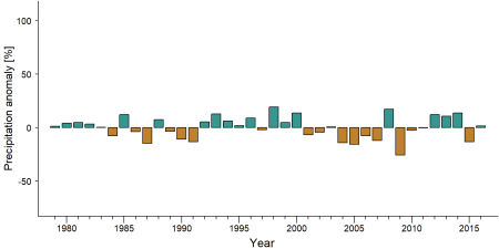
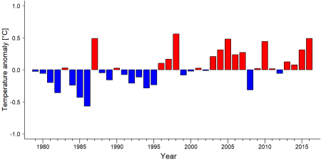
As part of a study on the exposure of African great ape sites to climate change impacts, Kiribou et al. | As part of a study on the exposure of African great ape sites to climate change impacts, [[#R02341|Kiribou et al. (2024)]] extracted climate data and data on projected extreme climate impact events for the site. Climatological characteristics were derived from observation-based climate data provided by the Inter-Sectoral Impact Model Intercomparison Project (ISIMIP, www.isimip.org). Parameters were calculated as the average across each 30-year period. For 1981-2010, the EWEMBI dataset from ISIMIP2a was used. For the two future periods (2021-2050 and 2071-2099) ISIMIP2b climate data based on four CMIP5 global climate models were used. For future projections, two Representative Concentration Pathways (RCP) were used. RCP 2.6 is a scenario with strong mitigation measures in which global temperatures would likely rise below 2C. RCP 6.0 is a scenario with medium emissions in which global temperatures would likely rise up to 3C by 2100. For the number of days with heavy precipitation events, the 98th percentile of all precipitation days (>1mm/d) was calculated for the 1979-2013 reference period as a threshold for a heavy precipitation event. Then, for each year, the number of days above that threshold was derived. The figures on temperature and precipitation anomaly show the deviation from the mean temperature and mean precipitation for the 1979-2013 reference period. | ||
The estimated exposure to future extreme climate impact events (crop failure, drought, river flood, wildfire, tropical cyclone, and heatwave) is based on a published dataset by Lange et al. 2020 derived from ISIMIP2b data. The same global climate models and RCPs as described above were used. Within each 30-year period, the number of years with an extreme event and the average proportion of the site affected were calculated ( | The estimated exposure to future extreme climate impact events (crop failure, drought, river flood, wildfire, tropical cyclone, and heatwave) is based on a published dataset by Lange et al. 2020 derived from ISIMIP2b data. The same global climate models and RCPs as described above were used. Within each 30-year period, the number of years with an extreme event and the average proportion of the site affected were calculated ([[#R02341|Kiribou et al. 2024]]). | ||
'''Table 8. Estimated past and projected climatological characteristics in Wonegizi Proposed Protected Area''' | '''Table 8. Estimated past and projected climatological characteristics in Wonegizi Proposed Protected Area''' | ||
| Line 462: | Line 462: | ||
= References = | = References = | ||
AllAfrica. 2019. Liberia: The Potentials of Wonegizi As a Protected Area. Online: https://allafrica.com/stories/201902080620.html | <span id="R01947"></span>AllAfrica. 2019. Liberia: The Potentials of Wonegizi As a Protected Area. Online: https://allafrica.com/stories/201902080620.html | ||
FFI. 2016. Community-based Conservation: the Wonegizi REDD+ pilot. | <span id="R01948"></span>FFI. 2016. Community-based Conservation: the Wonegizi REDD+ pilot. | ||
BirdLife International. 2019. Important Bird Areas factsheet: Wonegizi mountains. Downloaded from http://www.birdlife.org on 01/07/2019. | <span id="R01949"></span>BirdLife International. 2019. Important Bird Areas factsheet: Wonegizi mountains. Downloaded from http://www.birdlife.org on 01/07/2019. | ||
IUCN. 2015. How a single Pygmy Hippo photo gave rise to the Wonegizi Proposed Protected Area Project. Online: https://www.iucn.org/content/how-single-pygmy-hippo-photo-gave-rise-wonegizi-proposed-protected-area-project | <span id="R01950"></span>IUCN. 2015. How a single Pygmy Hippo photo gave rise to the Wonegizi Proposed Protected Area Project. Online: https://www.iucn.org/content/how-single-pygmy-hippo-photo-gave-rise-wonegizi-proposed-protected-area-project | ||
<span id="R02341"></span>Kiribou, R., Tehoda, P., Chukwu, O., Bempah, G., Kühl, H. S., Ferreira, J., …, & Heinicke, S. (2024). Exposure of African ape sites to climate change impacts. ''PLOS Climate'', 3(2), e0000345. [https://doi.org/10.1371/journal.pclm.0000345 doi:10.1371/journal.pclm.0000345] | |||
'''Page created by: '''Andrew Bamford''' Date:''' 2024-09-05 | '''Page created by: '''Andrew Bamford''' Date:''' 2024-09-05 | ||
Latest revision as of 17:55, 15 October 2026
West Africa > Liberia > Wonegizi Proposed Protected Area
Français | Português | Español | Bahasa Indonesia | Melayu
Summary
- Western chimpanzees (Pan troglodytes verus) are present in Wonegizi Proposed Protected Area.
- The population size is unknown.
- The chimpanzee population trend is unknown.
- This site has a total size of 1,374 km².
- Key threats to chimpanzees are poaching, logging, and shifting agriculture.
- Wonegizi was selected for a REDD+ pilot project led by Flora & Fauna International.
Site characteristics
The site is located in the northwestern part of the country, bordering Guinea’s Ziama Biosphere reserve. Wonegizi Proposed Protected Area is part of the Upper Guinean forest ecosystem, which is very rich in biodiversity. In addition to the critically endangered western chimpanzee (Pan troglodytes verus), the site contains other threatened and vulnerable species, including Jentink's duiker (Cephalophus jentinki), pygmy hippopotamus (Choeropsis liberiensis), Diana monkey (Cercopithecus diana), red colobus (Piliocolobus badius), green-tailed bristlebill (Bleda eximius), yellow-bearded greenbul (Criniger olivaceus), Nimba flycatcher (Melaenornis annamarulae), and the white-necked rockfowl or picathartes (Picathartes gymnocephalus, AllAfrica 2019, FFI). The site is also an Important Bird Area (IBA; BirdLife International 2019).
Table 1. Basic site information for Wonegizi Proposed Protected Area
| Species | Pan troglodytes verus |
| Area | 1,374.27 km² |
| Coordinates | Lat: 8.14 , Lon: -9.53 |
| Type of site | Proposed protected area |
| Habitat types | Subtropical/tropical moist lowland forest, Subtropical/tropical moist montane forest |
| Type of governance |
Types of sites Governance types Habitat types
Ape status
Camera traps have recorded the presence of chimpanzees at the site, but the population size remains unknown (IUCN 2015).
Table 2. Ape population estimates reported for Wonegizi Proposed Protected Area
| Species | Year | Occurrence | Encounter or vistation rate (nests/km; ind/day) | Density estimate [ind./ km²] (95% CI) | Abundance estimate (95% CI) | Survey area | Sampling method | Analytical framework | Source | Comments | A.P.E.S. database ID |
|---|---|---|---|---|---|---|---|---|---|---|---|
| Pan troglodytes verus | 2023 | Present | Wonegizi | Reconnaissance walk | Fauna & Flora | Community monitoring patrols suggest encounter rate of nests is stable 2021-2023. | |||||
| Pan troglodytes verus | 2020 | Present | Wonegizi | Camera trap | Fauna & Flora | ||||||
| Pan troglodytes verus | 2015 | Present | Wonegizi | Camera trap, Reconnaissance walk | IUCN 2015 |
Sampling methods Analytical frameworks
Threats
In addition to poaching and logging, the site is threatened by farming activities, in particular shifting cultivation (FFI 2016). Rice is the main crop and primary driver of land conversion in the area; other crops include chilli peppers and cacao (FFI 2016).
Table 3. Threats to apes reported for Wonegizi Proposed Protected Area
| Category | Specific threats | Threat level | Description | Year of threat |
|---|---|---|---|---|
| 1 Residential & commercial development | 1.1 Residential areas | Low (up to 30% of population affected) | Human settlements present (AllAfrica 2019). | Ongoing (2019) |
| 2 Agriculture & aquaculture | 2.1.1 Shifting agriculture | High (more than 70% of population affected) | Unsustainable farming practices, primarily shifting agriculture (FFI 2016). | Ongoing (2016) |
| 5 Biological resource use | 5.1 Hunting & collecting terrestrial animals | Present (unknown severity) | Bushmeat hunting and trade present in the area (FFI 2016). | Ongoing (2016) |
| 5 Biological resource use | 5.1.2 Unintentional effects | Low (up to 30% of population affected) | Community patrol encounter rates of snares (0.12 per km), spent cartridges (0.27 per km) and hunting camps (0.005 per km) on are stable between 2021 and 2023. Chimps are not specifically targeted (Bamford pers. comm. 2024). | 2021-2023 |
| 5 Biological resource use | 5.3 Logging & wood harvesting | Present (unknown severity) | Extraction of timber (FFI 2016). | Ongoing (2016) |
| 5 Biological resource use | 5.3.1 Subsistence logging | Medium (30-70% of population affected) | 6 km2 (1.6% total area of the PPA) of forest lost between 2000-2023, most after 2013 (Bamford pers. comm. 2024). | 2000-2023 |
Conservation activities
Wonegizi is a REDD+ pilot site. The project follows a community-based approach, in which forest protection is rewarded under the Reducing Emissions from Deforestation and Forest Degradation mechanism (REDD+). Income from the sale of REDD+ carbon credits is used to fund activities that benefit the communities, including the provision of technical support for reducing deforestation due to agriculture whilst increasing agricultural output, establishment of tree nurseries, and salaried forest protection as an alternative income (FFI 2016).
Table 4. Conservation activities reported for Wonegizi Proposed Protected Area
| Category | Specific activity | Description | Implementing organization(s) | Year of activity |
|---|---|---|---|---|
| 2 Counter-wildlife crime | 2.11 Implement monitoring surveillance strategies (e.g., SMART) or use monitoring data to improve effectiveness of patrols | Bamford pers. comm. 2024 | Fauna & Flora | Ongoing (2024) |
| 2 Counter-wildlife crime | 2.12 Implement community control of patrolling, banning hunting and removing snares | Bamford pers. comm. 2024 | Fauna & Flora | Ongoing (2024) |
| 2 Counter-wildlife crime | 2.13 Provide sustainable alternative livelihoods; establish fish- or domestic meat farms | Bamford pers. comm. 2024 | Fauna & Flora | Ongoing (2024) |
| 2 Counter-wildlife crime | 2.6 Regularly de-activate/remove ground snares | Bamford pers. comm. 2024 | Fauna & Flora | Ongoing (2024) |
| 4 Education & awareness | 4.2 Involve local community in ape research and conservation management | Bamford pers. comm. 2024 | Fauna & Flora | Ongoing (2024) |
| 5 Protection & restoration | 5.2 Legally protect ape habitat | Bamford pers. comm. 2024 | Fauna & Flora | Ongoing (2024) |
| 5 Protection & restoration | 5.5 Demarcate and enforce boundaries of protected areas | Bamford pers. comm. 2024 | Fauna & Flora | Ongoing (2024) |
| 7 Economic & other incentives | 7.1 Provide monetary benefits to local communities for sustainably managing their forest and its wildlife (e.g., REDD, alternative income, employment) | Bamford pers. comm. 2024 | Fauna & Flora | Ongoing (2024) |
| 8 Permanent presence | 8.3 Permanent presence of staff/manager | Bamford pers. comm. 2024 | Fauna & Flora | Ongoing (2024) |
Challenges
Table 5. Challenges reported for Wonegizi Proposed Protected Area
| Challenges | Specific challenges | Source | Year(s) |
|---|---|---|---|
| 2 Resources and capacity | 2.3 General lack of funding | FFI 2016 | |
| Unknown |
Enablers
Table 6. Enablers reported for Wonegizi Proposed Protected Area
| Enablers | Specific enablers | Source | Year(s) |
|---|---|---|---|
| 1 Site management | |||
| 2 Resources and capacity | |||
| 3 Engaged community | |||
| 4 Institutional support | |||
| 5 Ecological context | |||
| 6 Safety and stability |
Research activities
No information on research activities has been documented.
Documented behaviours
Table 7. Behaviours documented for Wonegizi Proposed Protected Area
| Category | Behavior | Observation type | Prevalence | Observation dates | Source | Habituation | Species | Comment |
|---|---|---|---|---|---|---|---|---|
| Not reported | ||||||||
| Not reported |
Exposure to climate change impacts
As part of a study on the exposure of African great ape sites to climate change impacts, Kiribou et al. (2024) extracted climate data and data on projected extreme climate impact events for the site. Climatological characteristics were derived from observation-based climate data provided by the Inter-Sectoral Impact Model Intercomparison Project (ISIMIP, www.isimip.org). Parameters were calculated as the average across each 30-year period. For 1981-2010, the EWEMBI dataset from ISIMIP2a was used. For the two future periods (2021-2050 and 2071-2099) ISIMIP2b climate data based on four CMIP5 global climate models were used. For future projections, two Representative Concentration Pathways (RCP) were used. RCP 2.6 is a scenario with strong mitigation measures in which global temperatures would likely rise below 2C. RCP 6.0 is a scenario with medium emissions in which global temperatures would likely rise up to 3C by 2100. For the number of days with heavy precipitation events, the 98th percentile of all precipitation days (>1mm/d) was calculated for the 1979-2013 reference period as a threshold for a heavy precipitation event. Then, for each year, the number of days above that threshold was derived. The figures on temperature and precipitation anomaly show the deviation from the mean temperature and mean precipitation for the 1979-2013 reference period.
The estimated exposure to future extreme climate impact events (crop failure, drought, river flood, wildfire, tropical cyclone, and heatwave) is based on a published dataset by Lange et al. 2020 derived from ISIMIP2b data. The same global climate models and RCPs as described above were used. Within each 30-year period, the number of years with an extreme event and the average proportion of the site affected were calculated (Kiribou et al. 2024).
Table 8. Estimated past and projected climatological characteristics in Wonegizi Proposed Protected Area
| Value | 1981-2010 | 2021-2050, RCP 2.6 | 2021-2050, RCP 6.0 | 2071-2099, RCP 2.6 | 2071-2099, RCP 6.0 |
|---|---|---|---|---|---|
| Mean temperature [C] | 24.6 | 25.8 | 25.7 | 25.8 | 27 |
| Annual precipitation [mm] | 2639 | 2668 | 2715 | 2752 | 2843 |
| Max no. consecutive dry days (per year) | 27.6 | 30.9 | 30 | 31.1 | 35.1 |
| No. days with heavy precipitation (per year) | 6.4 | 7.3 | 7.4 | 7.3 | 8.5 |
Table 9. Projected exposure of apes to extreme climate impact events in Wonegizi Proposed Protected Area
| Type | No. of years with event (2021-2050, RCP 2.6) | % of site exposed (2021-2050, RCP 2.6) | No. of years with event (2021-2050, RCP 6.0) | % of site exposed (2021-2050, RCP 6.0) | No. of years with event (2070-2099, RCP 2.6) | % of site exposed (2070-2099, RCP 2.6) | No. of years with event (2070-2099, RCP 6.0) | % of site exposed (2070-2099, RCP 6.0) |
|---|---|---|---|---|---|---|---|---|
| Crop failure | 5.5 | 0.04 | 5 | 0.05 | 3.5 | 0.04 | 8.5 | 0.05 |
| Drought | 0 | 0 | 0 | 0 | 0 | 0 | 0 | 0 |
| Heatwave | 11 | 100 | 6.5 | 100 | 11 | 100 | 9.5 | 100 |
| River flood | 1.5 | 0.83 | 1.5 | 0.6 | 1.5 | 2.7 | 4 | 1.42 |
| Tropical cyclone | 0 | 0 | 0 | 0 | 0 | 0 | 0 | 0 |
| Wildfire | 30 | 0.7 | 30 | 0.71 | 29 | 0.72 | 29 | 0.74 |
-
Precipitation anomaly in Wonegizi Proposed Protected Area -
Temperature anomaly in Wonegizi Proposed Protected Area


External links
References
AllAfrica. 2019. Liberia: The Potentials of Wonegizi As a Protected Area. Online: https://allafrica.com/stories/201902080620.html
FFI. 2016. Community-based Conservation: the Wonegizi REDD+ pilot.
BirdLife International. 2019. Important Bird Areas factsheet: Wonegizi mountains. Downloaded from http://www.birdlife.org on 01/07/2019.
IUCN. 2015. How a single Pygmy Hippo photo gave rise to the Wonegizi Proposed Protected Area Project. Online: https://www.iucn.org/content/how-single-pygmy-hippo-photo-gave-rise-wonegizi-proposed-protected-area-project
Kiribou, R., Tehoda, P., Chukwu, O., Bempah, G., Kühl, H. S., Ferreira, J., …, & Heinicke, S. (2024). Exposure of African ape sites to climate change impacts. PLOS Climate, 3(2), e0000345. doi:10.1371/journal.pclm.0000345
Page created by: Andrew Bamford Date: 2024-09-05