
Rumpi Hills Forest Reserve: Difference between revisions
Created page with "Central Africa > Cameroon > Rumpi Hills Forest Reserve '''[https://apesatlas-iucnapesportal-org.translate.goog/index.php/Rumpi_Hills_Forest_Reserve?_x_tr_sl=auto&_x_tr_tl=fr&_x_tr_hl=en&_x_tr_pto=wapp Français]''' | '''[https://apesatlas-iucnapesportal-org.translate.goog/index.php/Rumpi_Hills_Forest_Reserve?_x_tr_sl=auto&_x_tr_tl=pt&_x_tr_hl=en&_x_tr_pto=wapp Português]''' | '''[https://apesatlas-iucnapesportal-org.translate.goog/index.php/Rumpi_Hills_Fore..." |
No edit summary Tag: Manual revert |
||
| (8 intermediate revisions by the same user not shown) | |||
| Line 7: | Line 7: | ||
<div style='float: right'>{{#display_map: height=190px | width=300px | scrollzoom=off | zoom=5 | layers=OpenStreetMap,OpenTopoMap|4.909959, 9.153059~[[Rumpi Hills Forest Reserve]]~''Pan troglodytes ellioti'', ''Gorilla gorilla diehli''}}</div> | <div style='float: right'>{{#display_map: height=190px | width=300px | scrollzoom=off | zoom=5 | layers=OpenStreetMap,OpenTopoMap|4.909959, 9.153059~[[Rumpi Hills Forest Reserve]]~''Pan troglodytes ellioti'', ''Gorilla gorilla diehli''}}</div> | ||
* Nigeria-Cameroon chimpanzees (''Pan troglodytes ellioti | * Nigeria-Cameroon chimpanzees (''Pan troglodytes ellioti'') are present in Rumpi Hills Forest Reserve. | ||
* The population | * The population size is unknown. | ||
* The | * The population trend is unknown. | ||
* The site has a total size of 455 km². | * The site has a total size of 455 km². | ||
* Key threats to great apes are human encroachment, agricultural expansion, collection of NFTPs and hunting. | * Key threats to great apes are human encroachment, agricultural expansion, collection of NFTPs and hunting. | ||
* Conservation activities have focused on community forest monitoring. | * Conservation activities have focused on community forest monitoring. | ||
= Site characteristics = | = Site characteristics = | ||
Rumpi Hills Forest Reserve (RHFR) is situated in western Cameroon, to the north of Mount Cameroon and south of Korup National Park. The site includes a number of peaks over 1,000 m, the highest of which is Mount Rata at 1,768 m (Mukete et al. 2018). RHFR was created in 1941; previously it was known as the Rumpi Hills Native Administration Forest Reserve. The site is composed of land belonging to the Ngolo, Bima, and Balue ethnic groups (Mukete et al. 2018). RHFR comprises an area of mid-altitude forest, part of which has been degraded by logging and agricultural encroachment. Mount Rata has more intact forest than the surroundings. Coastal evergreen and semi-evergreen forest elements are also found at the reserve, as well as many permanent watercourses (BirdLife International 2001). The site is designated as an Important Bird Area (BirdLife International 2001) and a Key Biodiversity Area (Key Biodiversity Areas Partnership 2020). Over 198 bird species have been recorded at the site, including the endangered white-throated mountain-babbler (''Kupeornis gilberti''), white-necked pigeon (''Columba albinucha'') and green-breasted bush-shrike (''Malaconotus gladia-tor''). Additionally, a number of tropical montane mammal, reptile and amphibian species such as the endangered mandrill (Mandrillus leucophaeus), forest shrew (''Myosorex rumpii''), crested porcupine (''Hystrix cristata'') and hairy frog (''Trichobatrachus robustus'') have been identified at RHFR (Mukete et al. 2018, BirdLife International 2001). | Rumpi Hills Forest Reserve (RHFR) is situated in western Cameroon, to the north of Mount Cameroon and south of Korup National Park. The site includes a number of peaks over 1,000 m, the highest of which is Mount Rata at 1,768 m ([[#R01562|Mukete et al. 2018]]). RHFR was created in 1941; previously it was known as the Rumpi Hills Native Administration Forest Reserve. The site is composed of land belonging to the Ngolo, Bima, and Balue ethnic groups ([[#R01562|Mukete et al. 2018]]). RHFR comprises an area of mid-altitude forest, part of which has been degraded by logging and agricultural encroachment. Mount Rata has more intact forest than the surroundings. Coastal evergreen and semi-evergreen forest elements are also found at the reserve, as well as many permanent watercourses ([[#R01560|BirdLife International 2001]]). The site is designated as an Important Bird Area ([[#R01560|BirdLife International 2001]]) and a Key Biodiversity Area ([[#R01561|Key Biodiversity Areas Partnership 2020]]). Over 198 bird species have been recorded at the site, including the endangered white-throated mountain-babbler (''Kupeornis gilberti''), white-necked pigeon (''Columba albinucha'') and green-breasted bush-shrike (''Malaconotus gladia-tor''). Additionally, a number of tropical montane mammal, reptile and amphibian species such as the endangered mandrill (Mandrillus leucophaeus), forest shrew (''Myosorex rumpii''), crested porcupine (''Hystrix cristata'') and hairy frog (''Trichobatrachus robustus'') have been identified at RHFR ([[#R01562|Mukete et al. 2018]], [[#R01560|BirdLife International 2001]]). | ||
'''Table 1. Basic site information for Rumpi Hills Forest Reserve''' | '''Table 1. Basic site information for Rumpi Hills Forest Reserve''' | ||
| Line 44: | Line 41: | ||
[[Types of sites]] [[Governance types]] [[Habitat types]] | [[Types of sites]] [[Governance types]] [[Habitat types]] | ||
= Ape status = | = Ape status = | ||
| Line 63: | Line 61: | ||
!A.P.E.S. database ID | !A.P.E.S. database ID | ||
|- | |- | ||
| | |''Pan troglodytes ellioti'' | ||
| | | | ||
| | | | ||
| Line 78: | Line 76: | ||
[[Sampling methods]] [[Analytical frameworks]] | [[Sampling methods]] [[Analytical frameworks]] | ||
= Threats = | = Threats = | ||
During the 14-year-period between 2000 and 2014, the major land cover changes observed at RHFR were a decrease in dense forest cover and increase in areas under farmlands and secondary forest (Mukete et al. 2018). This change occurred mostly around villages in lower altitudes along the southern and western borders of the RHFR. In the eastern and northern borders, a majority of the villages are located on hilly terrain; since these topographical conditions do not favor agricultural expansion, the households are mainly involved in hunting, NTFPs and wood collection (Mukete et al. 2018). | During the 14-year-period between 2000 and 2014, the major land cover changes observed at RHFR were a decrease in dense forest cover and increase in areas under farmlands and secondary forest ([[#R01562|Mukete et al. 2018]]). This change occurred mostly around villages in lower altitudes along the southern and western borders of the RHFR. In the eastern and northern borders, a majority of the villages are located on hilly terrain; since these topographical conditions do not favor agricultural expansion, the households are mainly involved in hunting, NTFPs and wood collection ([[#R01562|Mukete et al. 2018]]). | ||
'''Table 3. Threats to apes reported for Rumpi Hills Forest Reserve''' | '''Table 3. Threats to apes reported for Rumpi Hills Forest Reserve''' | ||
| Line 89: | Line 88: | ||
!Description | !Description | ||
!Year of threat | !Year of threat | ||
|- | |||
|1 Residential & commercial development | |||
|1.1 Residential areas | |||
|High (more than 70% of population affected) | |||
| | |||
|Ongoing (2018) | |||
|- | |- | ||
|2 Agriculture & aquaculture | |2 Agriculture & aquaculture | ||
|2.1 Annual & perennial non-timber crops | |2.1 Annual & perennial non-timber crops | ||
|High (more than 70% of population affected) | |High (more than 70% of population affected) | ||
|Agro-industry farming (Key Biodiversity Areas Partnership 2020). Between 2000 and 2014, the main land cover change consisted of a decrease in dense forest cover and increase in farmland and secondary forest (Mukete et al. 2018). | |Agro-industry farming ([[#R01561|Key Biodiversity Areas Partnership 2020]]). Between 2000 and 2014, the main land cover change consisted of a decrease in dense forest cover and increase in farmland and secondary forest ([[#R01562|Mukete et al. 2018]]). | ||
|2000-2014, Ongoing (2020) | |2000-2014, Ongoing (2020) | ||
|- | |- | ||
| Line 99: | Line 104: | ||
|5.1 Hunting & collecting terrestrial animals | |5.1 Hunting & collecting terrestrial animals | ||
|High (more than 70% of population affected) | |High (more than 70% of population affected) | ||
|High hunting pressure (BirdLife International 2001). Villages on the eastern and northern borders are more involved in hunting, since the terrain does not favor agricultural expansion (Mukete et al. 2018). | |High hunting pressure ([[#R01560|BirdLife International 2001]]). Villages on the eastern and northern borders are more involved in hunting, since the terrain does not favor agricultural expansion ([[#R01562|Mukete et al. 2018]]). | ||
|2001-Ongoing (2018) | |2001-Ongoing (2018) | ||
|- | |- | ||
|5 Biological resource use | |5 Biological resource use | ||
|5. | |5.2 Gathering terrestrial plants | ||
|High (more than 70% of population affected) | |High (more than 70% of population affected) | ||
| | |NTFPs collected include bush mango (''Irvingia gabonsensis''), bitter cola (''Garcinia cola''), njansang (''Ricinodendron heudelotii''), country onion (''Afrostyrax lepido-phyllus''), bush pepper (''Piper guineense''), land snails (''Archachatina marginata'') and a variety of mushroom species ([[#R01562|Mukete et al. 2018]]). | ||
| | |||
|Ongoing (2018) | |Ongoing (2018) | ||
|- | |- | ||
|5 Biological resource use | |5 Biological resource use | ||
|5. | |5.3 Logging & wood harvesting | ||
|High (more than 70% of population affected) | |High (more than 70% of population affected) | ||
| | |The reserve has been open to logging concessions; much of the forest has been logged or is in a poor state ([[#R01560|BirdLife International 2001]]). | ||
|Ongoing ( | |Ongoing (2001) | ||
|- | |- | ||
|6 Human intrusions & disturbance | |6 Human intrusions & disturbance | ||
|6.3 Other human disturbances | |6.3 Other human disturbances | ||
|Medium (30-70% of population affected) | |Medium (30-70% of population affected) | ||
|Work and other activities (Key Biodiversity Areas Partnership 2020) | |Work and other activities ([[#R01561|Key Biodiversity Areas Partnership 2020]]) | ||
|Ongoing (2020) | |Ongoing (2020) | ||
|} | |} | ||
[[Threats]] | [[Threats]] | ||
= Conservation activities = | = Conservation activities = | ||
A project was implemented with the aim of establishing effective community forest monitoring by integrating Global Forest Watch (GFW) data and Participatory 3-Dimensional Mapping (P3DM) in the Western Cameroon Highlands Ecoregion. The African Conservation Foundation (ACF) and the Environment and Rural Development Foundation (ERuDeF), supported by the Waterloo Foundation and Global Forest Watch conducted this project ([https://africanconservation.org/cameroon-s-first-participatory-3d-mapping-for-forest-monitoring-and-conservation-management/ ACF]). | A project was implemented with the aim of establishing effective community forest monitoring by integrating Global Forest Watch (GFW) data and Participatory 3-Dimensional Mapping (P3DM) in the Western Cameroon Highlands Ecoregion. The African Conservation Foundation (ACF) and the Environment and Rural Development Foundation (ERuDeF), supported by the Waterloo Foundation and Global Forest Watch conducted this project ([https://africanconservation.org/cameroon-s-first-participatory-3d-mapping-for-forest-monitoring-and-conservation-management/ ACF]). | ||
= Challenges = | = Challenges = | ||
| Line 150: | Line 151: | ||
[[Challenges]] | [[Challenges]] | ||
= Enablers = | = Enablers = | ||
| Line 193: | Line 195: | ||
[[Enablers]] | [[Enablers]] | ||
= Research activities = | = Research activities = | ||
| Line 225: | Line 229: | ||
[[Behaviours]] | [[Behaviours]] | ||
= Exposure to climate change impacts = | = Exposure to climate change impacts = | ||
As part of a study on the exposure of African great ape sites to climate change impacts, Kiribou et al. | As part of a study on the exposure of African great ape sites to climate change impacts, [[#R02305|Kiribou et al. (2024)]] extracted climate data and data on projected extreme climate impact events for the site. Climatological characteristics were derived from observation-based climate data provided by the Inter-Sectoral Impact Model Intercomparison Project (ISIMIP, www.isimip.org). Parameters were calculated as the average across each 30-year period. For 1981-2010, the EWEMBI dataset from ISIMIP2a was used. For the two future periods (2021-2050 and 2071-2099) ISIMIP2b climate data based on four CMIP5 global climate models were used. For future projections, two Representative Concentration Pathways (RCP) were used. RCP 2.6 is a scenario with strong mitigation measures in which global temperatures would likely rise below 2C. RCP 6.0 is a scenario with medium emissions in which global temperatures would likely rise up to 3C by 2100. For the number of days with heavy precipitation events, the 98th percentile of all precipitation days (>1mm/d) was calculated for the 1979-2013 reference period as a threshold for a heavy precipitation event. Then, for each year, the number of days above that threshold was derived. The figures on temperature and precipitation anomaly show the deviation from the mean temperature and mean precipitation for the 1979-2013 reference period. | ||
The estimated exposure to future extreme climate impact events (crop failure, drought, river flood, wildfire, tropical cyclone, and heatwave) is based on a published dataset by Lange et al. 2020 derived from ISIMIP2b data. The same global climate models and RCPs as described above were used. Within each 30-year period, the number of years with an extreme event and the average proportion of the site affected were calculated ( | The estimated exposure to future extreme climate impact events (crop failure, drought, river flood, wildfire, tropical cyclone, and heatwave) is based on a published dataset by Lange et al. 2020 derived from ISIMIP2b data. The same global climate models and RCPs as described above were used. Within each 30-year period, the number of years with an extreme event and the average proportion of the site affected were calculated ([[#R02305|Kiribou et al. 2024]]). | ||
'''Table 8. Estimated past and projected climatological characteristics in Rumpi Hills Forest Reserve''' | '''Table 8. Estimated past and projected climatological characteristics in Rumpi Hills Forest Reserve''' | ||
| Line 314: | Line 319: | ||
|River flood | |River flood | ||
|2 | |2 | ||
|0. | |0.56 | ||
|1 | |1 | ||
|0.8 | |0.8 | ||
| Line 343: | Line 348: | ||
|} | |} | ||
<div><ul><li style="display: inline-block; vertical-align: top;"> [[File:PrecipAnomaly_Rumpi_Hills.png| 450px | thumb| none | Precipitation anomaly in Rumpi Hills Forest Reserve]] </li><li style="display: inline-block; vertical-align: top;"> [[File:TempAnomaly_Rumpi_Hills.png | 450px | thumb| none | Temperature anomaly in Rumpi Hills Forest Reserve]] </li></ul></div> | |||
= External links = | = External links = | ||
| Line 350: | Line 357: | ||
= References = | = References = | ||
BirdLife International (2001) Important Bird Areas factsheet: Mount Rata and Rumpi Hills Forest Reserve. Downloaded from http://www.birdlife.org on 05/01/2022. | <span id="R01560"></span>BirdLife International (2001) Important Bird Areas factsheet: Mount Rata and Rumpi Hills Forest Reserve. Downloaded from http://www.birdlife.org on 05/01/2022. | ||
<span id="R01561"></span>Key Biodiversity Areas Partnership (2020) Key Biodiversity Areas factsheet: Mount Rata and Rumpi Hills Forest Reserve. Extracted from the World Database of Key Biodiversity Areas. Developed by the Key Biodiversity Areas Partnership: BirdLife International, IUCN, American Bird Conservancy, Amphibian Survival Alliance, Conservation International, Critical Ecosystem Partnership Fund, Global Environment Facility, Global Wildlife Conservation, NatureServe, Rainforest Trust, Royal Society for the Protection of Birds, World Wildlife Fund and Wildlife Conservation Society. Downloaded from http://www.keybiodiversityareas.org/ on 05/01/2022. | |||
<span id="R01562"></span>Mukete, B., Yujun, S., Etongo, D., Saeed, S., & Mannan, A. (2018). Assessing the drivers of land use change in the Rumpi hills forest protected area, Cameroon. Journal of Sustainable Forestry, 37(6), 592-618. [https://doi.org/10.1080/10549811.2018.1449121 doi:10.1080/10549811.2018.1449121] | |||
<span id="R02305"></span>Kiribou, R., Tehoda, P., Chukwu, O., Bempah, G., Kühl, H. S., Ferreira, J., …, & Heinicke, S. (2024). Exposure of African ape sites to climate change impacts. ''PLOS Climate'', 3(2), e0000345. [https://doi.org/10.1371/journal.pclm.0000345 doi:10.1371/journal.pclm.0000345] | |||
'''Page created by: '''APES Atlas Team''' Date:''' 2022-01-10 | '''Page created by: '''APES Atlas Team''' Date:''' 2022-01-10 | ||
Latest revision as of 17:54, 15 October 2026
Central Africa > Cameroon > Rumpi Hills Forest Reserve
Français | Português | Español | Bahasa Indonesia | Melayu
Summary
- Nigeria-Cameroon chimpanzees (Pan troglodytes ellioti) are present in Rumpi Hills Forest Reserve.
- The population size is unknown.
- The population trend is unknown.
- The site has a total size of 455 km².
- Key threats to great apes are human encroachment, agricultural expansion, collection of NFTPs and hunting.
- Conservation activities have focused on community forest monitoring.
Site characteristics
Rumpi Hills Forest Reserve (RHFR) is situated in western Cameroon, to the north of Mount Cameroon and south of Korup National Park. The site includes a number of peaks over 1,000 m, the highest of which is Mount Rata at 1,768 m (Mukete et al. 2018). RHFR was created in 1941; previously it was known as the Rumpi Hills Native Administration Forest Reserve. The site is composed of land belonging to the Ngolo, Bima, and Balue ethnic groups (Mukete et al. 2018). RHFR comprises an area of mid-altitude forest, part of which has been degraded by logging and agricultural encroachment. Mount Rata has more intact forest than the surroundings. Coastal evergreen and semi-evergreen forest elements are also found at the reserve, as well as many permanent watercourses (BirdLife International 2001). The site is designated as an Important Bird Area (BirdLife International 2001) and a Key Biodiversity Area (Key Biodiversity Areas Partnership 2020). Over 198 bird species have been recorded at the site, including the endangered white-throated mountain-babbler (Kupeornis gilberti), white-necked pigeon (Columba albinucha) and green-breasted bush-shrike (Malaconotus gladia-tor). Additionally, a number of tropical montane mammal, reptile and amphibian species such as the endangered mandrill (Mandrillus leucophaeus), forest shrew (Myosorex rumpii), crested porcupine (Hystrix cristata) and hairy frog (Trichobatrachus robustus) have been identified at RHFR (Mukete et al. 2018, BirdLife International 2001).
Table 1. Basic site information for Rumpi Hills Forest Reserve
| Species | Pan troglodytes ellioti, Gorilla gorilla diehli |
| Area | 455 km² |
| Coordinates | Lat: 4.909959 , Lon: 9.153059 |
| Type of site | Protected area (Forest Reserve) |
| Habitat types | Subtropical/tropical moist montane forest, Wetlands (lakes, rivers, streams, bogs, marshes), Subtropical/tropical heavily degraded former forest, Agricultural land |
| Type of governance |
Types of sites Governance types Habitat types
Ape status
Table 2. Ape population estimates reported for Rumpi Hills Forest Reserve
| Species | Year | Occurrence | Encounter or vistation rate (nests/km; ind/day) | Density estimate [ind./ km²] (95% CI) | Abundance estimate (95% CI) | Survey area | Sampling method | Analytical framework | Source | Comments | A.P.E.S. database ID |
|---|---|---|---|---|---|---|---|---|---|---|---|
| Pan troglodytes ellioti | Rumpi Hills Forest Reserve |
Sampling methods Analytical frameworks
Threats
During the 14-year-period between 2000 and 2014, the major land cover changes observed at RHFR were a decrease in dense forest cover and increase in areas under farmlands and secondary forest (Mukete et al. 2018). This change occurred mostly around villages in lower altitudes along the southern and western borders of the RHFR. In the eastern and northern borders, a majority of the villages are located on hilly terrain; since these topographical conditions do not favor agricultural expansion, the households are mainly involved in hunting, NTFPs and wood collection (Mukete et al. 2018).
Table 3. Threats to apes reported for Rumpi Hills Forest Reserve
| Category | Specific threats | Threat level | Description | Year of threat |
|---|---|---|---|---|
| 1 Residential & commercial development | 1.1 Residential areas | High (more than 70% of population affected) | Ongoing (2018) | |
| 2 Agriculture & aquaculture | 2.1 Annual & perennial non-timber crops | High (more than 70% of population affected) | Agro-industry farming (Key Biodiversity Areas Partnership 2020). Between 2000 and 2014, the main land cover change consisted of a decrease in dense forest cover and increase in farmland and secondary forest (Mukete et al. 2018). | 2000-2014, Ongoing (2020) |
| 5 Biological resource use | 5.1 Hunting & collecting terrestrial animals | High (more than 70% of population affected) | High hunting pressure (BirdLife International 2001). Villages on the eastern and northern borders are more involved in hunting, since the terrain does not favor agricultural expansion (Mukete et al. 2018). | 2001-Ongoing (2018) |
| 5 Biological resource use | 5.2 Gathering terrestrial plants | High (more than 70% of population affected) | NTFPs collected include bush mango (Irvingia gabonsensis), bitter cola (Garcinia cola), njansang (Ricinodendron heudelotii), country onion (Afrostyrax lepido-phyllus), bush pepper (Piper guineense), land snails (Archachatina marginata) and a variety of mushroom species (Mukete et al. 2018). | Ongoing (2018) |
| 5 Biological resource use | 5.3 Logging & wood harvesting | High (more than 70% of population affected) | The reserve has been open to logging concessions; much of the forest has been logged or is in a poor state (BirdLife International 2001). | Ongoing (2001) |
| 6 Human intrusions & disturbance | 6.3 Other human disturbances | Medium (30-70% of population affected) | Work and other activities (Key Biodiversity Areas Partnership 2020) | Ongoing (2020) |
Conservation activities
A project was implemented with the aim of establishing effective community forest monitoring by integrating Global Forest Watch (GFW) data and Participatory 3-Dimensional Mapping (P3DM) in the Western Cameroon Highlands Ecoregion. The African Conservation Foundation (ACF) and the Environment and Rural Development Foundation (ERuDeF), supported by the Waterloo Foundation and Global Forest Watch conducted this project (ACF).
Challenges
Table 5. Challenges reported for Rumpi Hills Forest Reserve
| Challenges | Specific challenges | Source | Year(s) |
|---|---|---|---|
| Not reported |
Enablers
Table 6. Enablers reported for Rumpi Hills Forest Reserve
| Enablers | Specific enablers | Source | Year(s) |
|---|---|---|---|
| 1 Site management | |||
| 2 Resources and capacity | |||
| 3 Engaged community | |||
| 4 Institutional support | |||
| 5 Ecological context | |||
| 6 Safety and stability |
Research activities
Documented behaviours
Table 7. Behaviours documented for Rumpi Hills Forest Reserve
| Category | Behavior | Observation type | Prevalence | Observation dates | Source | Habituation | Species | Comment |
|---|---|---|---|---|---|---|---|---|
| Not reported |
Exposure to climate change impacts
As part of a study on the exposure of African great ape sites to climate change impacts, Kiribou et al. (2024) extracted climate data and data on projected extreme climate impact events for the site. Climatological characteristics were derived from observation-based climate data provided by the Inter-Sectoral Impact Model Intercomparison Project (ISIMIP, www.isimip.org). Parameters were calculated as the average across each 30-year period. For 1981-2010, the EWEMBI dataset from ISIMIP2a was used. For the two future periods (2021-2050 and 2071-2099) ISIMIP2b climate data based on four CMIP5 global climate models were used. For future projections, two Representative Concentration Pathways (RCP) were used. RCP 2.6 is a scenario with strong mitigation measures in which global temperatures would likely rise below 2C. RCP 6.0 is a scenario with medium emissions in which global temperatures would likely rise up to 3C by 2100. For the number of days with heavy precipitation events, the 98th percentile of all precipitation days (>1mm/d) was calculated for the 1979-2013 reference period as a threshold for a heavy precipitation event. Then, for each year, the number of days above that threshold was derived. The figures on temperature and precipitation anomaly show the deviation from the mean temperature and mean precipitation for the 1979-2013 reference period.
The estimated exposure to future extreme climate impact events (crop failure, drought, river flood, wildfire, tropical cyclone, and heatwave) is based on a published dataset by Lange et al. 2020 derived from ISIMIP2b data. The same global climate models and RCPs as described above were used. Within each 30-year period, the number of years with an extreme event and the average proportion of the site affected were calculated (Kiribou et al. 2024).
Table 8. Estimated past and projected climatological characteristics in Rumpi Hills Forest Reserve
| Value | 1981-2010 | 2021-2050, RCP 2.6 | 2021-2050, RCP 6.0 | 2071-2099, RCP 2.6 | 2071-2099, RCP 6.0 |
|---|---|---|---|---|---|
| Mean temperature [C] | 24.9 | 26 | 26 | 26.2 | 27.2 |
| Annual precipitation [mm] | 2605 | 2679 | 2721 | 2743 | 2691 |
| Max no. consecutive dry days (per year) | 36.9 | 29.4 | 30.6 | 27.1 | 31.6 |
| No. days with heavy precipitation (per year) | 6.1 | 7.1 | 7.1 | 8.1 | 7.6 |
Table 9. Projected exposure of apes to extreme climate impact events in Rumpi Hills Forest Reserve
| Type | No. of years with event (2021-2050, RCP 2.6) | % of site exposed (2021-2050, RCP 2.6) | No. of years with event (2021-2050, RCP 6.0) | % of site exposed (2021-2050, RCP 6.0) | No. of years with event (2070-2099, RCP 2.6) | % of site exposed (2070-2099, RCP 2.6) | No. of years with event (2070-2099, RCP 6.0) | % of site exposed (2070-2099, RCP 6.0) |
|---|---|---|---|---|---|---|---|---|
| Crop failure | 4.5 | 0.1 | 4 | 0.18 | 2.5 | 0.1 | 2.5 | 0.05 |
| Drought | 0 | 0 | 0 | 0 | 0 | 0 | 0 | 0 |
| Heatwave | 5.5 | 100 | 8 | 100 | 5 | 100 | 7.5 | 100 |
| River flood | 2 | 0.56 | 1 | 0.8 | 1 | 1.93 | 4 | 1.31 |
| Tropical cyclone | 0 | 0 | 0 | 0 | 0 | 0 | 0 | 0 |
| Wildfire | 30 | 0.6 | 30 | 0.61 | 29 | 0.6 | 29 | 0.64 |
-
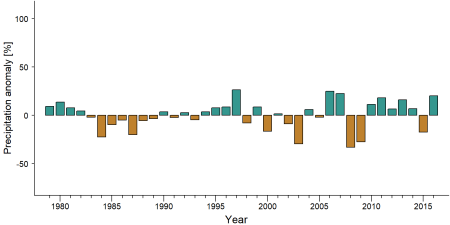
Precipitation anomaly in Rumpi Hills Forest Reserve -
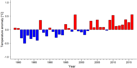
Temperature anomaly in Rumpi Hills Forest Reserve


External links
References
BirdLife International (2001) Important Bird Areas factsheet: Mount Rata and Rumpi Hills Forest Reserve. Downloaded from http://www.birdlife.org on 05/01/2022.
Key Biodiversity Areas Partnership (2020) Key Biodiversity Areas factsheet: Mount Rata and Rumpi Hills Forest Reserve. Extracted from the World Database of Key Biodiversity Areas. Developed by the Key Biodiversity Areas Partnership: BirdLife International, IUCN, American Bird Conservancy, Amphibian Survival Alliance, Conservation International, Critical Ecosystem Partnership Fund, Global Environment Facility, Global Wildlife Conservation, NatureServe, Rainforest Trust, Royal Society for the Protection of Birds, World Wildlife Fund and Wildlife Conservation Society. Downloaded from http://www.keybiodiversityareas.org/ on 05/01/2022.
Mukete, B., Yujun, S., Etongo, D., Saeed, S., & Mannan, A. (2018). Assessing the drivers of land use change in the Rumpi hills forest protected area, Cameroon. Journal of Sustainable Forestry, 37(6), 592-618. doi:10.1080/10549811.2018.1449121
Kiribou, R., Tehoda, P., Chukwu, O., Bempah, G., Kühl, H. S., Ferreira, J., …, & Heinicke, S. (2024). Exposure of African ape sites to climate change impacts. PLOS Climate, 3(2), e0000345. doi:10.1371/journal.pclm.0000345
Page created by: APES Atlas Team Date: 2022-01-10