
Grand Kru-River Gee Proposed Protected Area: Difference between revisions
No edit summary |
No edit summary |
||
| (3 intermediate revisions by the same user not shown) | |||
| Line 17: | Line 17: | ||
= Site characteristics = | = Site characteristics = | ||
This area preserves the only remaining location in Liberia that preserves an undeveloped corridor connecting the coastal environment with the interior wet evergreen forest (mix of primary and secondary forest and coastal marshes). It contains an important section of the upper Dugbe River watershed and tributaries (Yaza and Sinoe Creeks). The area contains approximately 40 kilometers of Atlantic Ocean coastline, and estuaries. It is known to support important populations of the vulnerable forest elephant ''Loxodonta africana'', zebra duiker ''Cephalophus zebra'', and pygmy hippopotamus ''Hexaprotodon liberiensis'', as well as the endangered Upper Guinea red colobus ''Piliocolobus badius'' (Johnson 2015). | This area preserves the only remaining location in Liberia that preserves an undeveloped corridor connecting the coastal environment with the interior wet evergreen forest (mix of primary and secondary forest and coastal marshes). It contains an important section of the upper Dugbe River watershed and tributaries (Yaza and Sinoe Creeks). The area contains approximately 40 kilometers of Atlantic Ocean coastline, and estuaries. It is known to support important populations of the vulnerable forest elephant ''Loxodonta africana'', zebra duiker ''Cephalophus zebra'', and pygmy hippopotamus ''Hexaprotodon liberiensis'', as well as the endangered Upper Guinea red colobus ''Piliocolobus badius'' ([[#R00657|Johnson 2015]]). | ||
'''Table 1. Basic site information for Grand Kru-River Gee Proposed Protected Area''' | '''Table 1. Basic site information for Grand Kru-River Gee Proposed Protected Area''' | ||
| Line 44: | Line 44: | ||
= Ape status = | = Ape status = | ||
No information about surveys in this area could be found. Tweh and colleagues (2014) surveyed two line transects in Grand-Kru River Gee Proposed Protected Area, however, they did not find chimpanzee nests or other signs of their presence (Junker unpubl. data). The nationwide chimpanzee abundance model published by Junker et al. (2015) suggests that chimpanzees probably only occur at (very) low densities in this area. Further analysis of the nationwide dataset revealed that Grand Kru-River Gee Proposed Protected Area was not located in a conservation priority area in terms of chimpanzee density, and mammal and tree diversity (Junker et al. 2015). Interview surveys showed that many villages near Grand Kru-River Gee Proposed Protected Area do not practice taboos against the killing or eating of chimpanzees (Junker unpubl. data). | No information about surveys in this area could be found. [[#R00659|Tweh and colleagues (2014)]] surveyed two line transects in Grand-Kru River Gee Proposed Protected Area, however, they did not find chimpanzee nests or other signs of their presence (Junker unpubl. data). The nationwide chimpanzee abundance model published by [[#R00658|Junker et al. (2015)]] suggests that chimpanzees probably only occur at (very) low densities in this area. Further analysis of the nationwide dataset revealed that Grand Kru-River Gee Proposed Protected Area was not located in a conservation priority area in terms of chimpanzee density, and mammal and tree diversity ([[#R00658|Junker et al. 2015]]). Interview surveys showed that many villages near Grand Kru-River Gee Proposed Protected Area do not practice taboos against the killing or eating of chimpanzees (Junker unpubl. data). | ||
'''Table 2. Ape population estimates reported for Grand Kru-River Gee Proposed Protected Area''' | '''Table 2. Ape population estimates reported for Grand Kru-River Gee Proposed Protected Area''' | ||
| Line 70: | Line 70: | ||
|Camera trap | |Camera trap | ||
| | | | ||
|FFI 2023 | |[[#R00655|FFI 2023]] | ||
| | | | ||
| | | | ||
| Line 83: | Line 83: | ||
|Other | |Other | ||
| | | | ||
|Junker et al. 2015 | |[[#R00658|Junker et al. 2015]] | ||
|Only 2 line transects surveyed, estimate based on a nationwide chimpanzee abundance model. Chimpanzees are likely to be present. | |Only 2 line transects surveyed, estimate based on a nationwide chimpanzee abundance model. Chimpanzees are likely to be present. | ||
| | | | ||
| Line 92: | Line 92: | ||
= Threats = | = Threats = | ||
During the nationwide chimpanzee and large mammal survey, teams surveyed two line transects and recces inside Grand Kru-River Gee Proposed Protected Area and encountered high amounts of hunting signs. The teams also did not find any large mammal tracks, except of humans ''Homo sapiens''. They also found signs of artisanal mining (Junker unpubl. data). A considerable part of the proposed protected area is covered by Mineral Exploration Licenses (MEL), Mineral Exploration Agreements (MEA), and Mineral Development Agreements (MDA) by various companies (Johnson 2015). It is unclear if/when mining activities will commence in the area. Grand Kru-River Gee Proposed Protected Area overlapped with illegally issued Private-Use Permits (PUPs) for commercial logging. Private Use Permits were a type of logging licence designed to allow private land owners to cut trees on their property, but which were reportedly subject to misuse by commercial logging companies. After investigations by Global Witness (Global Witness 2013) much public outcry and extensive media coverage, PUPs have now largely been rescinded (Johnson 2015). Additionally, the site also overlaps with a Proposed Forestry Concession (Junker et al. 2015). However, it is not clear if/when logging activities will commence. | During the nationwide chimpanzee and large mammal survey, teams surveyed two line transects and recces inside Grand Kru-River Gee Proposed Protected Area and encountered high amounts of hunting signs. The teams also did not find any large mammal tracks, except of humans ''Homo sapiens''. They also found signs of artisanal mining (Junker unpubl. data). A considerable part of the proposed protected area is covered by Mineral Exploration Licenses (MEL), Mineral Exploration Agreements (MEA), and Mineral Development Agreements (MDA) by various companies ([[#R00657|Johnson 2015]]). It is unclear if/when mining activities will commence in the area. Grand Kru-River Gee Proposed Protected Area overlapped with illegally issued Private-Use Permits (PUPs) for commercial logging. Private Use Permits were a type of logging licence designed to allow private land owners to cut trees on their property, but which were reportedly subject to misuse by commercial logging companies. After investigations by Global Witness ([[#R00656|Global Witness 2013]]) much public outcry and extensive media coverage, PUPs have now largely been rescinded ([[#R00657|Johnson 2015]]). Additionally, the site also overlaps with a Proposed Forestry Concession ([[#R00658|Junker et al. 2015]]). However, it is not clear if/when logging activities will commence. | ||
'''Table 3. Threats to apes reported for Grand Kru-River Gee Proposed Protected Area''' | '''Table 3. Threats to apes reported for Grand Kru-River Gee Proposed Protected Area''' | ||
| Line 105: | Line 105: | ||
|3.2.3 Artisanal mining | |3.2.3 Artisanal mining | ||
|High (more than 70% of population affected) | |High (more than 70% of population affected) | ||
|Mining for gold and other minerals (Johnson 2015), artisanal mining (Junker unpubl. data). Mining activities recorded on recce transects (Fauna & Flora 2023). | |Mining for gold and other minerals ([[#R00657|Johnson 2015]]), artisanal mining (Junker unpubl. data). Mining activities recorded on recce transects ([[#R00655|Fauna & Flora 2023]]). | ||
|2015-Ongoing (2023) | |2015-Ongoing (2023) | ||
|- | |- | ||
| Line 111: | Line 111: | ||
|5.1 Hunting & collecting terrestrial animals | |5.1 Hunting & collecting terrestrial animals | ||
|High (more than 70% of population affected) | |High (more than 70% of population affected) | ||
|Nationwide survey teams found many empty cartridges and snares and no large mammal tracks except of humans (Junker unpubl. data). Signs of hunting recorded on recce transects (Fauna & Flora 2023). | |Nationwide survey teams found many empty cartridges and snares and no large mammal tracks except of humans (Junker unpubl. data). Signs of hunting recorded on recce transects ([[#R00655|Fauna & Flora 2023]]). | ||
|2012-Ongoing (2023) | |2012-Ongoing (2023) | ||
|- | |- | ||
| Line 258: | Line 258: | ||
= Exposure to climate change impacts = | = Exposure to climate change impacts = | ||
As part of a study on the exposure of African great ape sites to climate change impacts, Kiribou et al. | As part of a study on the exposure of African great ape sites to climate change impacts, [[#R02206|Kiribou et al. (2024)]] extracted climate data and data on projected extreme climate impact events for the site. Climatological characteristics were derived from observation-based climate data provided by the Inter-Sectoral Impact Model Intercomparison Project (ISIMIP, www.isimip.org). Parameters were calculated as the average across each 30-year period. For 1981-2010, the EWEMBI dataset from ISIMIP2a was used. For the two future periods (2021-2050 and 2071-2099) ISIMIP2b climate data based on four CMIP5 global climate models were used. For future projections, two Representative Concentration Pathways (RCP) were used. RCP 2.6 is a scenario with strong mitigation measures in which global temperatures would likely rise below 2C. RCP 6.0 is a scenario with medium emissions in which global temperatures would likely rise up to 3C by 2100. For the number of days with heavy precipitation events, the 98th percentile of all precipitation days (>1mm/d) was calculated for the 1979-2013 reference period as a threshold for a heavy precipitation event. Then, for each year, the number of days above that threshold was derived. The figures on temperature and precipitation anomaly show the deviation from the mean temperature and mean precipitation for the 1979-2013 reference period. | ||
The estimated exposure to future extreme climate impact events (crop failure, drought, river flood, wildfire, tropical cyclone, and heatwave) is based on a published dataset by Lange et al. 2020 derived from ISIMIP2b data. The same global climate models and RCPs as described above were used. Within each 30-year period, the number of years with an extreme event and the average proportion of the site affected were calculated ( | The estimated exposure to future extreme climate impact events (crop failure, drought, river flood, wildfire, tropical cyclone, and heatwave) is based on a published dataset by Lange et al. 2020 derived from ISIMIP2b data. The same global climate models and RCPs as described above were used. Within each 30-year period, the number of years with an extreme event and the average proportion of the site affected were calculated ([[#R02206|Kiribou et al. 2024]]). | ||
'''Table 8. Estimated past and projected climatological characteristics in Grand Kru-River Gee Proposed Protected Area''' | '''Table 8. Estimated past and projected climatological characteristics in Grand Kru-River Gee Proposed Protected Area''' | ||
| Line 383: | Line 383: | ||
= References = | = References = | ||
Fauna & Flora (2023) Threat | <span id="R00655"></span>Fauna & Flora International (2023). Threat assessment of Cestos-Senkwehn and Grand Kru-River Gee proposed protected areas. Conservation Works/USAID. | ||
Global Witness. 2013. Avoiding the Riptide: Liberia must Enforce its Forest Laws to Prevent a New Wave of Illegal and Destructive Logging Contracts. Global Witness. | <span id="R00656"></span>Global Witness. 2013. Avoiding the Riptide: Liberia must Enforce its Forest Laws to Prevent a New Wave of Illegal and Destructive Logging Contracts. Global Witness. | ||
Johnson S. 2015. Aggregated Biodiversity Offsets: A Roadmap for Liberia’s Mining Sector. Unpublished report by the World Bank Group (WBG) and Program On Forests (PROFOR). | <span id="R00657"></span>Johnson S. 2015. Aggregated Biodiversity Offsets: A Roadmap for Liberia’s Mining Sector. Unpublished report by the World Bank Group (WBG) and Program On Forests (PROFOR). | ||
Junker J, Boesch C, Freeman T, Mundry R, Stephens C, Kühl | <span id="R00658"></span>Junker, J., Boesch, C., Freeman, T., Mundry, R., Stephens, C., & Kühl, H. S. (2015). Integrating wildlife conservation with conflicting economic land-use goals in a West African biodiversity hotspot. ''Basic and Applied Ecology'', 16(8), 690-702. [https://doi.org/10.1016/j.baae.2015.07.002 doi:10.1016/j.baae.2015.07.002] | ||
Tweh C, Lormie M, Kouakou | <span id="R00659"></span>Tweh, C. G., Lormie, M. M., Kouakou, C. Y., Hillers, A., Kühl, H. S., & Junker, J. (2015). Conservation status of chimpanzees Pan troglodytes verus and other large mammals in Liberia: a nationwide survey. ''Oryx'', 49(4), 710-718. [https://doi.org/10.1017/s0030605313001191 doi:10.1017/s0030605313001191] | ||
Wilson | <span id="R00660"></span>Wilson, S. T. K., Wang, H., Kabenge, M., & Qi, X. (2017). The mining sector of Liberia: current practices and environmental challenges. ''Environmental Science and Pollution Research'', 24(23), 18711-18720. [https://doi.org/10.1007/s11356-017-9647-4 doi:10.1007/s11356-017-9647-4] | ||
<span id="R02206"></span>Kiribou, R., Tehoda, P., Chukwu, O., Bempah, G., Kühl, H. S., Ferreira, J., …, & Heinicke, S. (2024). Exposure of African ape sites to climate change impacts. ''PLOS Climate'', 3(2), e0000345. [https://doi.org/10.1371/journal.pclm.0000345 doi:10.1371/journal.pclm.0000345] | |||
'''Page created by: '''Andrew Bamford''' Date:''' 2024-09-05 | '''Page created by: '''Andrew Bamford''' Date:''' 2024-09-05 | ||
Latest revision as of 17:53, 15 October 2026
West Africa > Liberia > Grand Kru-River Gee Proposed Protected Area
Français | Português | Español | Bahasa Indonesia | Melayu
Summary
- Western chimpanzees (Pan troglodytes verus) are likely to be present in Grand Kru-River Gee Proposed Protected Area at low densities.
- The population size is unknown.
- The chimpanzee population trend is unknown.
- This site has a total size of 1351 km².
- Key threats to chimpanzees are hunting, large-scale mining and commercial logging.
- Grand Kru-River Gee Proposed Protected Area spans three Key Biodiversity Areas: Grand Kru Southwest, -Northwest-, and the -Northeast forest blocks.
Site characteristics
This area preserves the only remaining location in Liberia that preserves an undeveloped corridor connecting the coastal environment with the interior wet evergreen forest (mix of primary and secondary forest and coastal marshes). It contains an important section of the upper Dugbe River watershed and tributaries (Yaza and Sinoe Creeks). The area contains approximately 40 kilometers of Atlantic Ocean coastline, and estuaries. It is known to support important populations of the vulnerable forest elephant Loxodonta africana, zebra duiker Cephalophus zebra, and pygmy hippopotamus Hexaprotodon liberiensis, as well as the endangered Upper Guinea red colobus Piliocolobus badius (Johnson 2015).
Table 1. Basic site information for Grand Kru-River Gee Proposed Protected Area
| Species | Pan troglodytes verus |
| Area | 1,351 km² |
| Coordinates | Lat: 4.87 , Lon: -8.54 |
| Type of site | Proposed protected area |
| Habitat types | Subtropical/tropical moist lowland forest, Grassland, Marine coastal/supratidal |
| Type of governance |
Types of sites Governance types Habitat types
Ape status
No information about surveys in this area could be found. Tweh and colleagues (2014) surveyed two line transects in Grand-Kru River Gee Proposed Protected Area, however, they did not find chimpanzee nests or other signs of their presence (Junker unpubl. data). The nationwide chimpanzee abundance model published by Junker et al. (2015) suggests that chimpanzees probably only occur at (very) low densities in this area. Further analysis of the nationwide dataset revealed that Grand Kru-River Gee Proposed Protected Area was not located in a conservation priority area in terms of chimpanzee density, and mammal and tree diversity (Junker et al. 2015). Interview surveys showed that many villages near Grand Kru-River Gee Proposed Protected Area do not practice taboos against the killing or eating of chimpanzees (Junker unpubl. data).
Table 2. Ape population estimates reported for Grand Kru-River Gee Proposed Protected Area
| Species | Year | Occurrence | Encounter or vistation rate (nests/km; ind/day) | Density estimate [ind./ km²] (95% CI) | Abundance estimate (95% CI) | Survey area | Sampling method | Analytical framework | Source | Comments | A.P.E.S. database ID |
|---|---|---|---|---|---|---|---|---|---|---|---|
| Pan troglodytes verus | 2023 | Present | Grand Kru-River Gee Proposed Protected Area | Camera trap | FFI 2023 | ||||||
| Pan troglodytes verus | 2010-2012 | Grand Kru-River Gee Proposed Protected Area | Other | Junker et al. 2015 | Only 2 line transects surveyed, estimate based on a nationwide chimpanzee abundance model. Chimpanzees are likely to be present. |
Sampling methods Analytical frameworks
Threats
During the nationwide chimpanzee and large mammal survey, teams surveyed two line transects and recces inside Grand Kru-River Gee Proposed Protected Area and encountered high amounts of hunting signs. The teams also did not find any large mammal tracks, except of humans Homo sapiens. They also found signs of artisanal mining (Junker unpubl. data). A considerable part of the proposed protected area is covered by Mineral Exploration Licenses (MEL), Mineral Exploration Agreements (MEA), and Mineral Development Agreements (MDA) by various companies (Johnson 2015). It is unclear if/when mining activities will commence in the area. Grand Kru-River Gee Proposed Protected Area overlapped with illegally issued Private-Use Permits (PUPs) for commercial logging. Private Use Permits were a type of logging licence designed to allow private land owners to cut trees on their property, but which were reportedly subject to misuse by commercial logging companies. After investigations by Global Witness (Global Witness 2013) much public outcry and extensive media coverage, PUPs have now largely been rescinded (Johnson 2015). Additionally, the site also overlaps with a Proposed Forestry Concession (Junker et al. 2015). However, it is not clear if/when logging activities will commence.
Table 3. Threats to apes reported for Grand Kru-River Gee Proposed Protected Area
| Category | Specific threats | Threat level | Description | Year of threat |
|---|---|---|---|---|
| 3 Energy production & mining | 3.2.3 Artisanal mining | High (more than 70% of population affected) | Mining for gold and other minerals (Johnson 2015), artisanal mining (Junker unpubl. data). Mining activities recorded on recce transects (Fauna & Flora 2023). | 2015-Ongoing (2023) |
| 5 Biological resource use | 5.1 Hunting & collecting terrestrial animals | High (more than 70% of population affected) | Nationwide survey teams found many empty cartridges and snares and no large mammal tracks except of humans (Junker unpubl. data). Signs of hunting recorded on recce transects (Fauna & Flora 2023). | 2012-Ongoing (2023) |
| 5 Biological resource use | 5.3 Logging & wood harvesting | High (more than 70% of population affected) | Area overlapped with Private-Use Permits, which have been withdrawn and with a Proposed Forestry Concession | Ongoing (2015) |
Conservation activities
No conservation activities have been reported for the site.
Table 4. Conservation activities reported for Grand Kru-River Gee Proposed Protected Area
| Category | Specific activity | Description | Implementing organization(s) | Year of activity |
|---|---|---|---|---|
| 5 Protection & restoration | 5.5 Demarcate and enforce boundaries of protected areas | Bamford pers. comm. 2024 | Ongoing (2024) |
Challenges
Table 5. Challenges reported for Grand Kru-River Gee Proposed Protected Area
| Challenges | Specific challenges | Source | Year(s) |
|---|---|---|---|
| Not reported | |||
| Unknown |
Enablers
Table 6. Enablers reported for Grand Kru-River Gee Proposed Protected Area
| Enablers | Specific enablers | Source | Year(s) |
|---|---|---|---|
| 1 Site management | |||
| 2 Resources and capacity | |||
| 3 Engaged community | |||
| 4 Institutional support | |||
| 5 Ecological context | |||
| 6 Safety and stability |
Research activities
Documented behaviours
Table 7. Behaviours documented for Grand Kru-River Gee Proposed Protected Area
| Category | Behavior | Observation type | Prevalence | Observation dates | Source | Habituation | Species | Comment |
|---|---|---|---|---|---|---|---|---|
| Not reported | ||||||||
| Not reported |
Exposure to climate change impacts
As part of a study on the exposure of African great ape sites to climate change impacts, Kiribou et al. (2024) extracted climate data and data on projected extreme climate impact events for the site. Climatological characteristics were derived from observation-based climate data provided by the Inter-Sectoral Impact Model Intercomparison Project (ISIMIP, www.isimip.org). Parameters were calculated as the average across each 30-year period. For 1981-2010, the EWEMBI dataset from ISIMIP2a was used. For the two future periods (2021-2050 and 2071-2099) ISIMIP2b climate data based on four CMIP5 global climate models were used. For future projections, two Representative Concentration Pathways (RCP) were used. RCP 2.6 is a scenario with strong mitigation measures in which global temperatures would likely rise below 2C. RCP 6.0 is a scenario with medium emissions in which global temperatures would likely rise up to 3C by 2100. For the number of days with heavy precipitation events, the 98th percentile of all precipitation days (>1mm/d) was calculated for the 1979-2013 reference period as a threshold for a heavy precipitation event. Then, for each year, the number of days above that threshold was derived. The figures on temperature and precipitation anomaly show the deviation from the mean temperature and mean precipitation for the 1979-2013 reference period.
The estimated exposure to future extreme climate impact events (crop failure, drought, river flood, wildfire, tropical cyclone, and heatwave) is based on a published dataset by Lange et al. 2020 derived from ISIMIP2b data. The same global climate models and RCPs as described above were used. Within each 30-year period, the number of years with an extreme event and the average proportion of the site affected were calculated (Kiribou et al. 2024).
Table 8. Estimated past and projected climatological characteristics in Grand Kru-River Gee Proposed Protected Area
| Value | 1981-2010 | 2021-2050, RCP 2.6 | 2021-2050, RCP 6.0 | 2071-2099, RCP 2.6 | 2071-2099, RCP 6.0 |
|---|---|---|---|---|---|
| Mean temperature [C] | 25.2 | 26.2 | 26.1 | 26.3 | 27.4 |
| Annual precipitation [mm] | 2752 | 2739 | 2852 | 2771 | 2827 |
| Max no. consecutive dry days (per year) | 15.3 | 16 | 14.5 | 15.8 | 15.2 |
| No. days with heavy precipitation (per year) | 6 | 11.1 | 11.6 | 11.2 | 13.9 |
Table 9. Projected exposure of apes to extreme climate impact events in Grand Kru-River Gee Proposed Protected Area
| Type | No. of years with event (2021-2050, RCP 2.6) | % of site exposed (2021-2050, RCP 2.6) | No. of years with event (2021-2050, RCP 6.0) | % of site exposed (2021-2050, RCP 6.0) | No. of years with event (2070-2099, RCP 2.6) | % of site exposed (2070-2099, RCP 2.6) | No. of years with event (2070-2099, RCP 6.0) | % of site exposed (2070-2099, RCP 6.0) |
|---|---|---|---|---|---|---|---|---|
| Crop failure | 2.5 | 0.02 | 1.5 | 0.02 | 2.5 | 0.02 | 3.5 | 0.02 |
| Drought | 0 | 0 | 0 | 0 | 0 | 0 | 0 | 0 |
| Heatwave | 11.5 | 100 | 10 | 100 | 15 | 100 | 17 | 100 |
| River flood | 0 | 0 | 1.25 | 1.77 | 0 | 0 | 0 | 0 |
| Tropical cyclone | 0 | 0 | 1 | 0.43 | 0 | 0 | 0 | 0 |
| Wildfire | 30 | 0.35 | 30 | 0.33 | 29 | 0.45 | 28.75 | 0.34 |
-
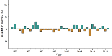
Precipitation anomaly in Grand Kru-River Gee Proposed Protected Area -
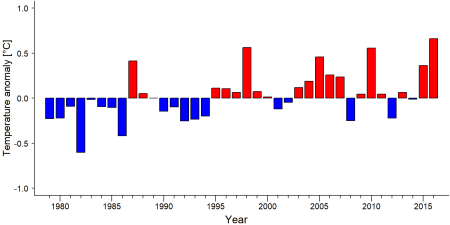
Temperature anomaly in Grand Kru-River Gee Proposed Protected Area


External links
References
Fauna & Flora International (2023). Threat assessment of Cestos-Senkwehn and Grand Kru-River Gee proposed protected areas. Conservation Works/USAID.
Global Witness. 2013. Avoiding the Riptide: Liberia must Enforce its Forest Laws to Prevent a New Wave of Illegal and Destructive Logging Contracts. Global Witness.
Johnson S. 2015. Aggregated Biodiversity Offsets: A Roadmap for Liberia’s Mining Sector. Unpublished report by the World Bank Group (WBG) and Program On Forests (PROFOR).
Junker, J., Boesch, C., Freeman, T., Mundry, R., Stephens, C., & Kühl, H. S. (2015). Integrating wildlife conservation with conflicting economic land-use goals in a West African biodiversity hotspot. Basic and Applied Ecology, 16(8), 690-702. doi:10.1016/j.baae.2015.07.002
Tweh, C. G., Lormie, M. M., Kouakou, C. Y., Hillers, A., Kühl, H. S., & Junker, J. (2015). Conservation status of chimpanzees Pan troglodytes verus and other large mammals in Liberia: a nationwide survey. Oryx, 49(4), 710-718. doi:10.1017/s0030605313001191
Wilson, S. T. K., Wang, H., Kabenge, M., & Qi, X. (2017). The mining sector of Liberia: current practices and environmental challenges. Environmental Science and Pollution Research, 24(23), 18711-18720. doi:10.1007/s11356-017-9647-4
Kiribou, R., Tehoda, P., Chukwu, O., Bempah, G., Kühl, H. S., Ferreira, J., …, & Heinicke, S. (2024). Exposure of African ape sites to climate change impacts. PLOS Climate, 3(2), e0000345. doi:10.1371/journal.pclm.0000345
Page created by: Andrew Bamford Date: 2024-09-05